What’s Oot Ma Windae?
Friends of Scottish Civic Trust, lovers of the built environment and folk self-isolating throughout Scotland:
Spending a little more time indoors these days? In search of an interesting way to pass the time? Finding yourself looking ever-longingly out the windows of your home?
We give you our new social media campaign #WhatsOotMaWindae! It’s simple:
- You post photos of the view from your windows at home – use the hashtag #WhatsOotMaWindae and tag us @scotcivictrust
- We’ll provide a little chat about the buildings you’re seeing or you share a bit with us about your area!
This way, we can still connect with our built heritage community & beyond during this difficult period of self-isolation and social distancing. We’ll be updating this post regularly and linking to our social media, so follow us on Facebook, Twitter and Instagram to keep up to date.
UPDATE: We’re so excited with the responses we’ve been getting, and we’re doing our best to respond to as many as possible, as quickly as possible. At our current capacity, we’ll write longer entries for 1 shot per day. Thanks for your understanding!
#WhatsOotMaWindae 46: Paisley
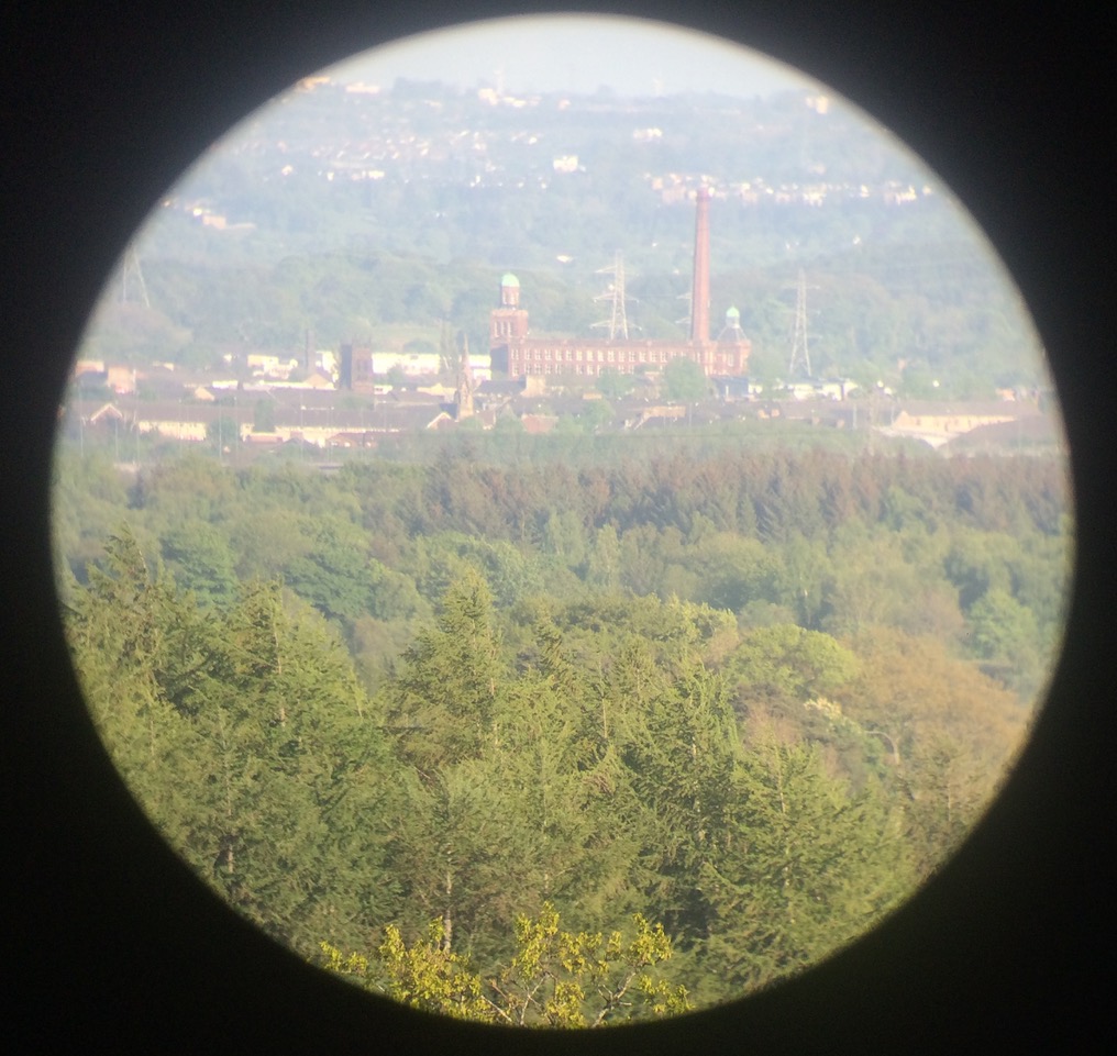
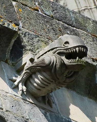
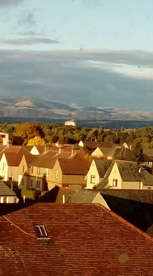
Photo 1: What a great shot sent in by one of our trustees – thanks Fiona Sinclair! She’s taken a shot of Paisley through her telescope and above the trees we can see the A-listed Paisley Abbey peeking up with the Abbey Mill Business Centre in the background. Paisley Abbey was founded in 1163, but the oldest remaining parts of the building date from the 13th century. However, during the Wars of Scottish Independence, Edward I of England had the Abbey burnt down in 1307 and much of it was destroyed. The destruction of the Abbey at the hands of the English was likely due to the Abbey’s ties to the Stewart family – at that time, the Stewarts were enemies of England as they supported Robert the Bruce‘s claim to the Scottish throne. Paisley Abbey received significant patronage from the Stewart family and as a result became a centre of medieval trade and learning. The Abbey also has another supposed connection to the Wars of Scottish Independence – it is said that William Wallace, born in nearby Elderslie, was educated by the monks at Paisley Abbey when he was young. Today, to memorialise this connection, there is a window depicting Wallace in the Abbey. The parts of the Abbey that survived the violence and destruction of the Wars of Scottish Independence served as the basis for rebuilding during the 14th century. Paisley Abbey claims to be the “Cradle of the Royal House of Stewart” because King Robert II of Scotland, the first of the Stewart monarchs, was born there in 1316. The reigning Queen Elizabeth II descends from the House of Stewart, and can trace her lineage back to Robert II of Scotland.
Photo 2: The Abbey fell on hard times with the original tower collapsed in the mid-16th century, destroying much of the Abbey. Due to the Reformation, the Abbey was left in ruins until restoration works began in the late 19th century. Our favourite architectural feature of the Abbey actually comes from a round of recent restoration work. Most of the Abbey’s gargoyles were replaced during the 1990s due to water damage (the original purpose of gargoyles was to serve as spouts carrying rainwater away from the building). Many have pointed out that one of the gargoyles looks strangely similar to the ‘xenomorph‘ creatures of Ridley Scott’s ‘Alien’ films. When asked about the origins behind the gargoyle’s design, a minister at the Abbey responded that he thinks “it was a stonemason having a bit of fun”!
#WhatsOotMaWindae 45: Academy Street, Inverness
#WhatsOotMaWindae 45: Academy Street, Inverness
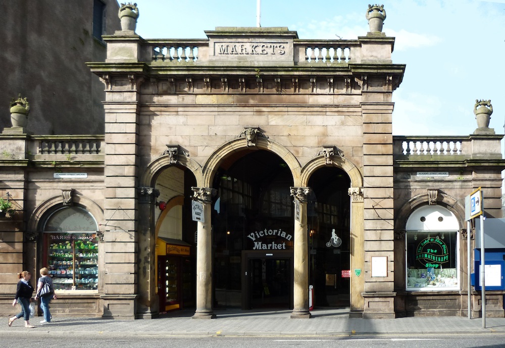
Photo 1: What a wonderful collection of built heritage in this picture, taken by the Academy Street Townscape Heritage Project (ASTHP). Academy Street is one of the oldest streets in Inverness. The street first took shape along the line of the defensive ditch that surrounded the medieval burgh. Academy Street remained on the outskirts of town until 1855 with the coming of the railway – at this time Station Square was built along Academy Street and Inverness’ railway station remains there today. The building on the immediate right of photo 1 is 33 Academy Street. It is B-listed, dating to 1895 and built in the style of the French Renaissance. Key features of the French Renaissance architectural style that you can see on this building include pilasters to divide the facade, round arches, a string course, mansard roof and dormer windows, all topped off with a pediment above the top floor central dormer window. 33 Academy Street has had a long commercial history – The ASTHP have found documentation listing the businesses that were housed here in the 1920s: a tailor, dressmakers, surveyors and timber merchants! You can see that 33 Academy Street still has pilastered shop fronts at the ground floor, continuing this mercantile tradition.
Photo 2: Further down the street on the righthand side, we can just make out the entrance to the B-listed Victorian Market, which we’ve added a closer-up photo of. The covered Victorian Market was built in 1869-1870 after the invention of gas lighting. Gas lighting enabled outdoor markets to be moved indoors, which provided a shopping experience shielded from the weather. Gas lighting also enabled the market to be open beyond daylight hours. However, this new light source was likely the cause of a massive fire that razed mot of the market to the ground. Fortunately, the Academy Street market entrance survived the fire (photo 2). This grand structure has Corinthian columns forming three entryway arches, each with sculpted animal head keystones. If you look closely, you can spot a bull’s head atop the central arch, flanked by ram’s heads on the side arches. The arches are topped by a balustraded parapet, with a central flagpole and decorative urns on each corner. Today, the Victorian Market remains a shopping area full of small independent retailers and cafes. To learn more about Academy Street and Inverness, check out the Academy Street Townscape Heritage Project’s new digital heritage trail here.
#WhatsOotMaWindae 44: St. Andrew’s in the Square, Glasgow
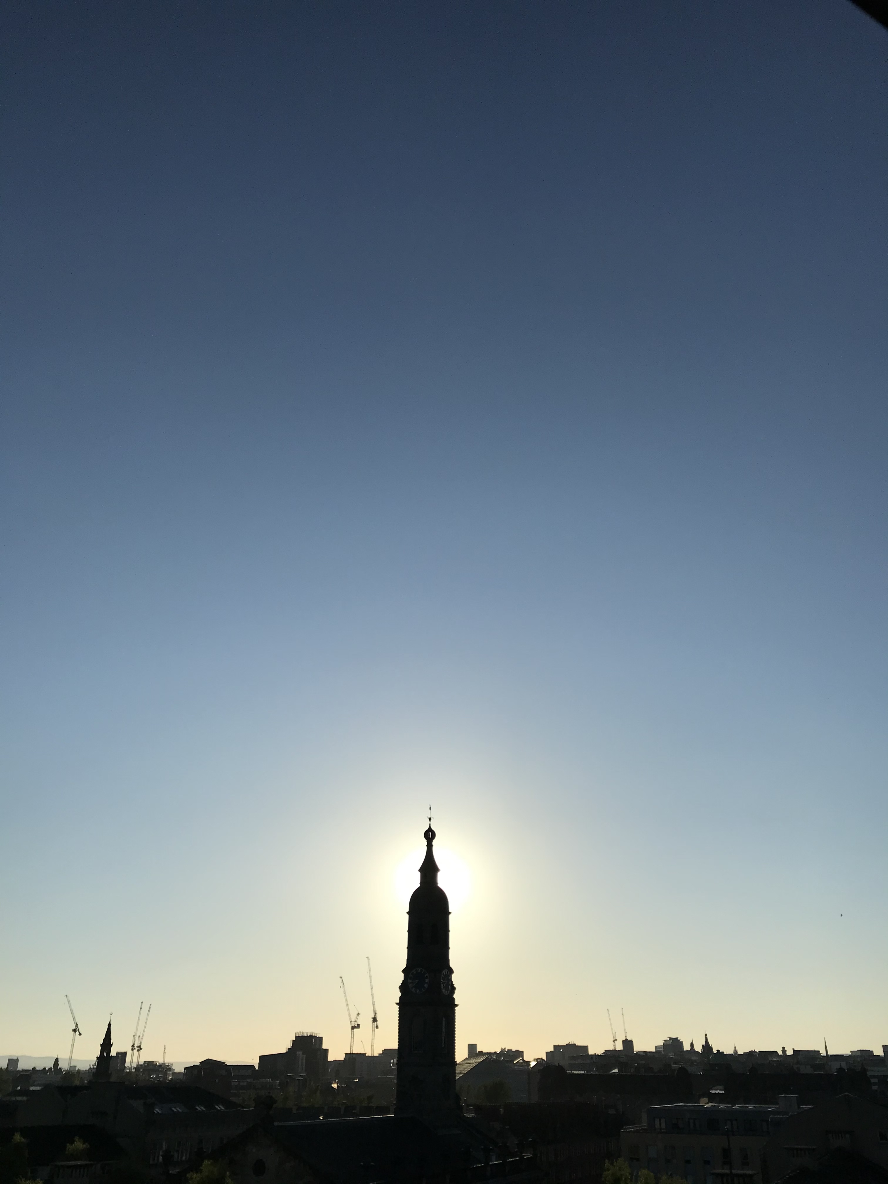
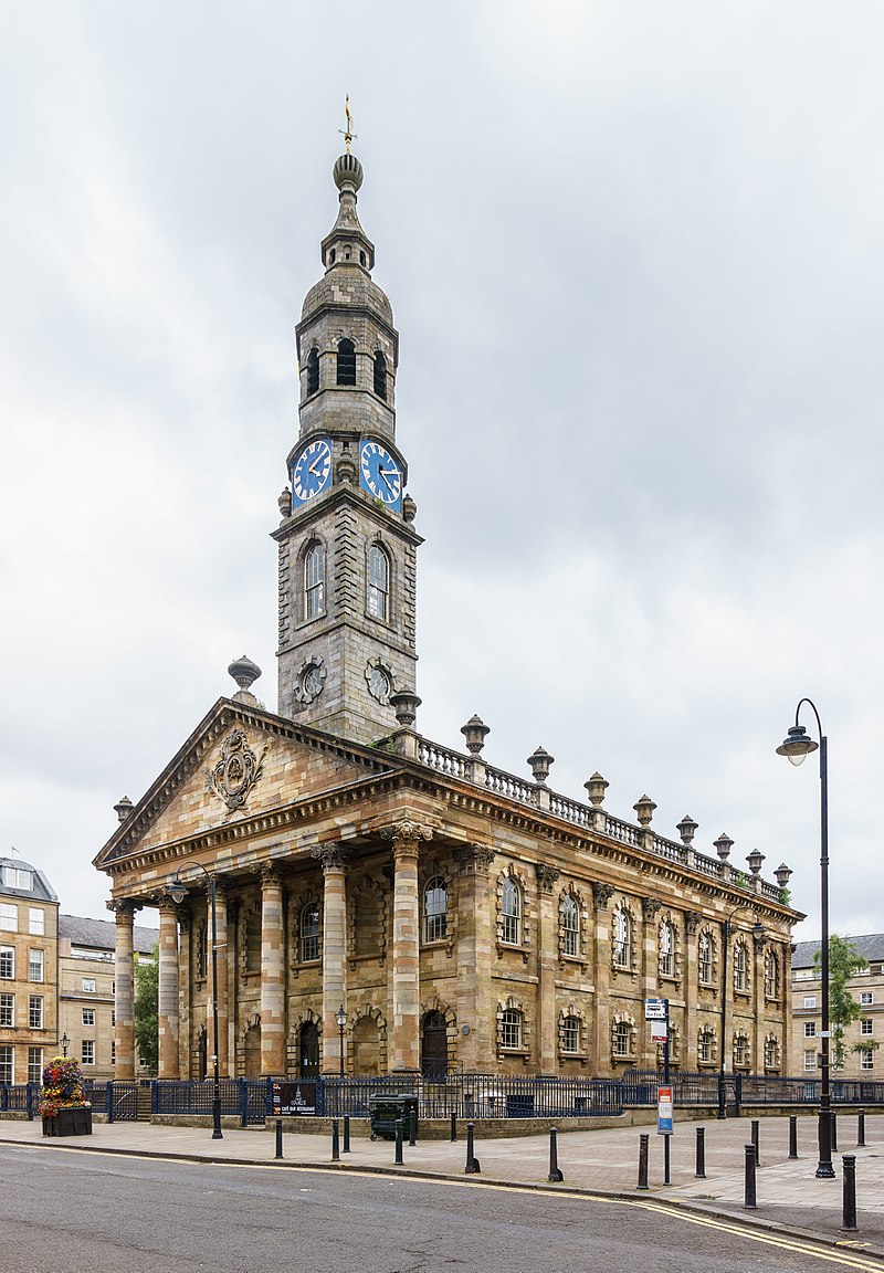
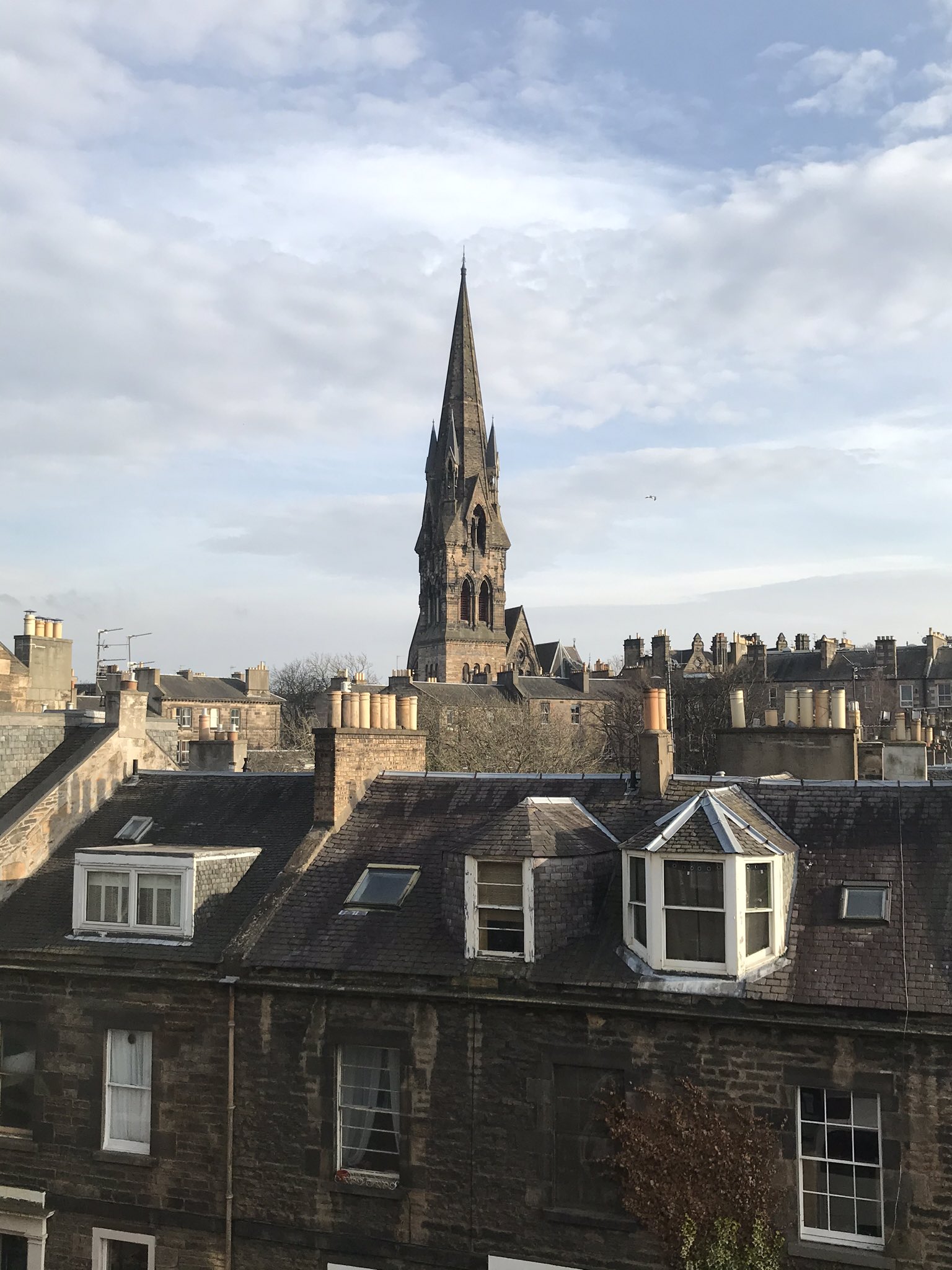
Photo 1: What an incredible view of Glasgow! We’re in awe of the beautifully varied horizon line of buildings, with spires, tenements and industrial buildings all popping up to say hi. The dominating, centre spire belongs to none other than St. Andrew’s in the Square, an A-listed marvel! This spire has 5-stages, or sections. Standing out particularly well here is the clockface on the third stage and the ball finial at the very top of the spire.
Photo 2: We’ve added another photograph of St. Andrew’s in the Square (© User:Colin), so that you can see its amazing architectural details. The building was designed by Allan Dreghorn in 1739, with construction finally finishing in 1756. Part of the construction delays were due to Bonnie Prince Charlie, whose army camped in the church’s partially-built walls during their retreat from Derby in December 1745. The architect Dreghorn took inspiration from James Gibbs’ St. Martin-in-the-Fields in London. Both buildings are of a rectilinear Neoclassical design and both have porticos with pediments on their front elevations, held up with a giant order of six Corinthian columns. Both buildings’ roofs are framed by a balustraded parapet, though St. Andrew’s in the Square takes the grand design a step further with the addition of a series of urn finials. Urn finials were a fashionable way to decorate posh houses in the 18th century, and one could find similar urn finials on the ‘Tobacco Lord‘ mansions that used to line Argyle Street. Scottish Civic Trust’s own Tobacco Merchant’s House, where our offices are based, is a Georgian townhouse of the same period and retains its urn finials, which you can see here.
Both St. Andrew’s in the Square and St. Martin-in-the-Fields also have massive spires. In fact, Glaswegians feared that St. Andrew’s in the Square’s spire and portico were too massive – when the scaffolding was first taken down, some were scared that the portico would collapse under the weight. But the buildings’s stonemason Mungo Naismith put their fears to bed by putting his own bed under the portico and sleeping the night there. To learn more about St. Andrew’s in the Square, check out this video by local historian Fergus Sutherland and the Calton Heritage Trail courtesy of Glasgow City Council.
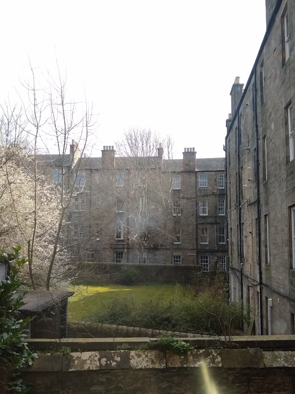
#WhatsOotMaWindae 43: Chessel’s Court, Edinburgh
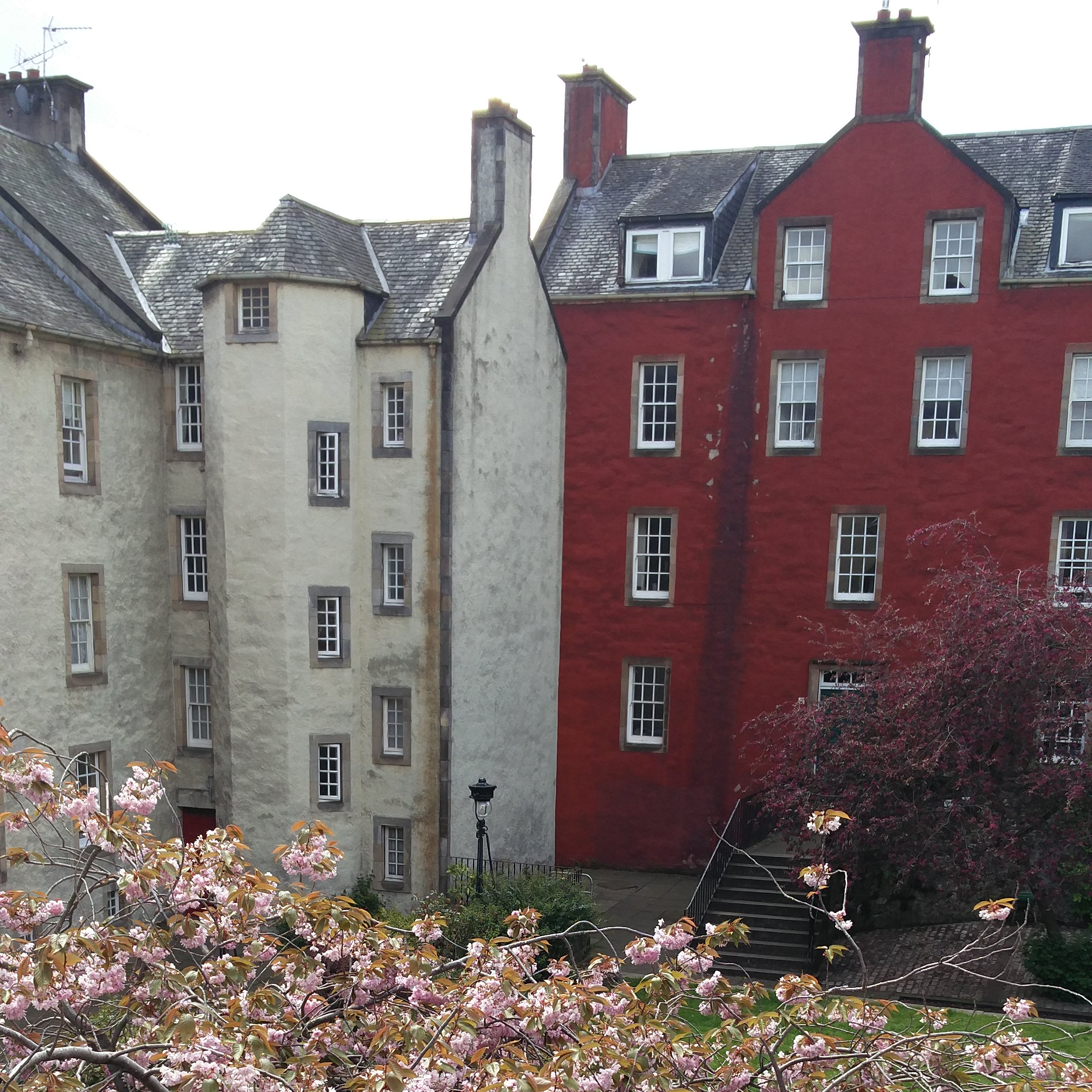
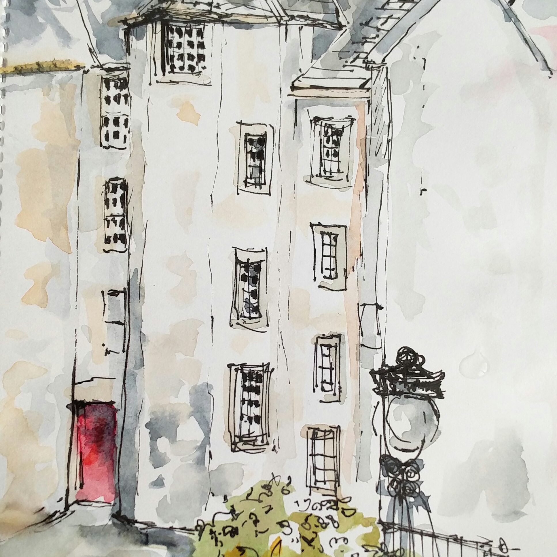
Thanks to one of our e-bulletin readers for sending in this awe-inspiring shot, as well as the amazing accompanying watercolour! The buildings we see here are a blast from the past – built back in the 18th century and full of historic architectural details. First up, we’d like to mention that turnpike stair protruding outward from the white building. ‘Turnpike’ is the Scots term for a spiral staircase, from the notion of the stair revolving round a central axis like a turnpike, or a a revolving set of spikes/bars (also known as a turnstile). This turnpike is located on the West wing of the South block of Chessel’s Court (the white building). The South block of Chessel’s Court was built in the 1740s, with the wings added in the 1760s to create a ‘U-plan’. According to Historic Environment Scotland, this building is a rare survival of traditional 18th century Edinburgh ‘mansion blocks’. Mansion blocks are blocks of flats with ornate facades, period features and high ceilings. Mansion blocks popped up in Edinburgh during the 18th and early 19th centuries when land in Edinburgh’s Old Town was becoming scarcer. At this time, blocks of flats, although a good way to house more people on less land area, were associated with the lower class. Builders tried to change this association and attract wealthier buyers to flats by creating ornately decorated ‘mansion blocks’.
The red building that you can also see in this photo is the West block of Chessel’s Court, which was built a few decades later around 1770. We especially like the dominating central wall head chimney, which beautifully reflects the white gable chimney to the left on the South block. Both the West and South blocks are constructed of harled rubble walls. Harling consists of lime mortar mixed with small stones or shells, which is cast against the wall and produces a rough textured finish. This tough wall finish protects stone walls from rough Scottish weather.
#WhatsOotMaWindae 42: Ayr
Here we have a lovely a terrace of B-listed, early 19th century houses situated along Alloway Place in Ayr. They are 2-storey and 3-bay (bays are the number of windows in a horizontal line across a facade). The stonework is painted ashlar, which is nicely contrasted by a vermiculated base course at the ground floor level (we’ve included a close up of this detail – see photo 2). Whereas the ashlar has a smooth finish, vermiculated stone has been cut into with a pattern of dense, irregular lines. ‘Vermiculation’ comes from the Latin word ‘vermiculus’ meaning ‘little worm’ because the pattern resembles worms or worm tracks. The vermiculation pattern can also be found other places in the natural world, such as in the feathers of certain birds. Some animals are even named after their vermiculation, such as the Siganus vermiculatus, commonly known as the maze rabbitfish. In nature, vermiculation provides camouflage and/or decoration to animals. In architecture, vermiculation adds texture and visual interest to a building, especially when contrasted with smooth ashlar. Other interesting stonework details that you can see on this terrace include two band courses, which are horizontal, decorative rows of stonework that extends across the front of a building – one is parallel with block-pediments of the doorpiece and the other with the 1st floor window cills.
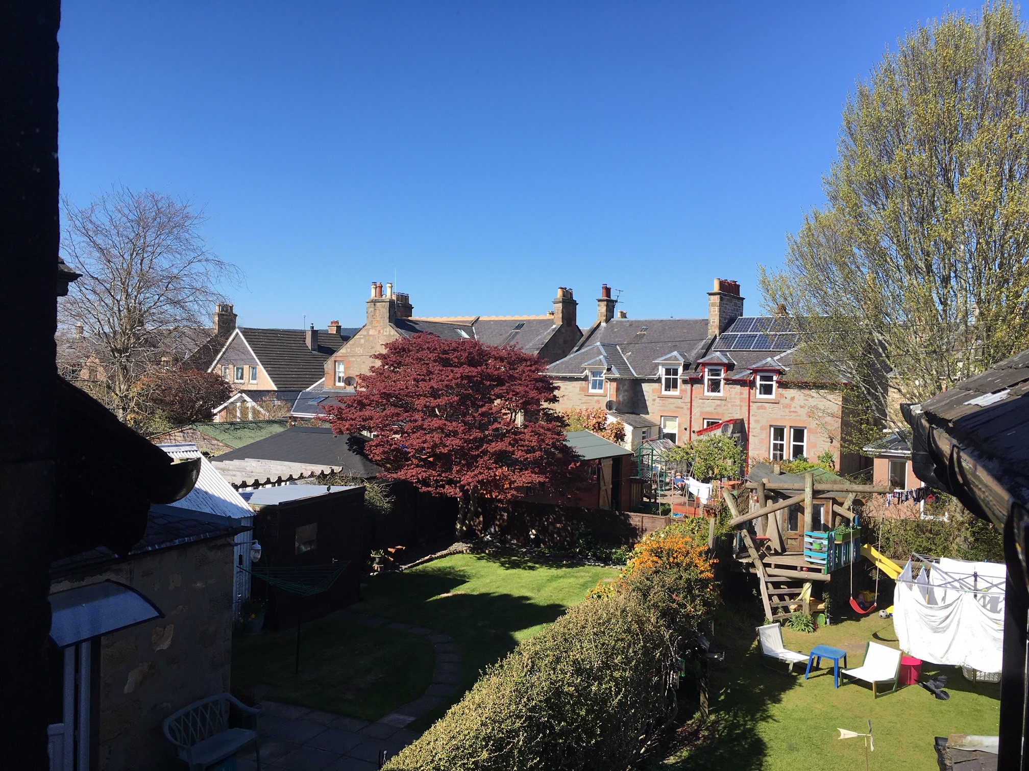
#WhatsOotMaWindae 41: Nairn, Highland
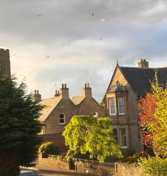
Photo 1: Today we’re travelling all the way up to Nairn, situated along the Moray Firth NE of Inverness. With sandy beaches and lovely weather (Nairn is one of the driest and sunniest places in Scotland!), it’s no wonder that Nairn has historically been a tourist destination for Scots. In the 19th century, Victorians flocked to Nairn not only for the weather, but also because the town’s seawaters were said to have medicinal properties. These Victorians also built amazing houses, like those we see here – what a pair of pretty stone houses these are! They have a lovely gentle pitch to the slate roof, with delicate timber detail over the upper windows. We adore the fine-cut stone reveals around the windows and door. Reveals are the side faces of an opening in a wall, between the door or window frame and the outer wall. Plus the windows are interesting – notice how the two houses have differing designs? It looks like perhaps the house on the right has kept and maintained its timber windows – a very elegant 2 over 2 design. It is also worth mentioning those rather dominating gate piers!
Photos 2 & 3: Well, we have to mention that church just peeping into the picture in the upper lefthand corner of photo 2. We suspect that this is the A-listed Old Parish Church (we’ve included a shot of this church for photo 3). The Old Parish Church is a stunning 19th century, double cruciform Gothic Church. ‘Double Cruciform’ means that the floorplan of the church is shaped like a double cross (☨), which you can see from this aerial shot. The main tower is 100 feet tall and you can see it has 4 stages, or sections. The top of the tower is finished with an impressive crenallated parapet. You can learn more about the building and its stunning interior (which has a 1903 organ with 1700 pipes!) here.
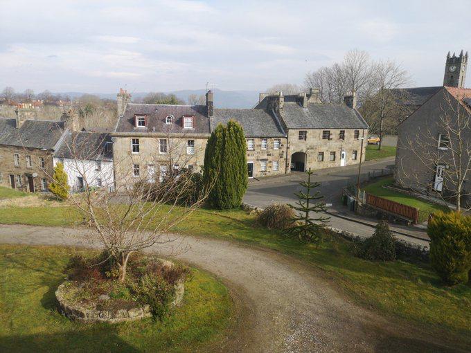
#WhatsOotMaWindae 40: Inveresk, East Lothian
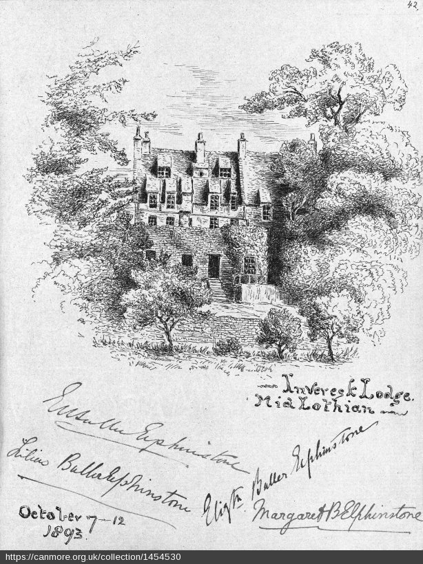
Photo 1: This is like a snapshot in time, with so many lovely clues from the past. In just this one shot, we can see: an industrial outhouse alongside remnants of the cottage industry of black smithing, both complemented the beautiful stone built houses beyond! In terms of the outhouse (lefthand building in foreground), we’re seeing that it’s constructed of corrugated sheeting, a hardy material. Corrugated sheeting was widely used in agricultural buildings as it was cheap, versatile and lasts many years – with good, regular maintenance of course! For the smiddy (righthand foreground with red tiled roof) – we would love to know about this? A wee online dig hasn’t uncovered anything yet! Lastly, for those stone houses in the distance – we are appreciating the undulating gables! These houses are located along Carberry Road, in Inveresk – a wee village with some amazing architectural history.
Photo 2: Inveresk village sits within a conservation area and has done since 1969. The first conservation area in Scotland was designated in 1968, making Inveresk one of the first. So what were people so eager to preserve, you ask? Well, Inveresk’s first settlement dates back to early Roman times, and the town has mostly remained unchanged from the 17th century. For example, Inveresk Lodge dates back to approximately 1683 and the lovley sketch of the site that you see above dates to 1893. According to the Inveresk Village Society, “Inveresk Lodge was owned by the Wedderburn family for over 100 years. Two of the family fought with the Jacobites during the 1745 Jacobite Rebellion, with one being captured and executed in London while the other, John, escaped to Jamaica, beginning the family’s strong business connections with the Caribbean. John’s son James bought the Lodge in 1775 after his return from Jamaica. Whilst in Jamaica, James had fathered several children by a slave girl called Rosanna, one of whom, Robert Wedderburn, travelled to Scotland and Inveresk to find his father. But a joyful reunion was not to be had; James Wedderburn refused to do anything for Robert and sent him away. In Robert’s words: ...he called me a lazy fellow and said he would do nothing for me. From his cook I had one small beer and his footman gave me a bent sixpence. Robert later went on to be one of the nation’s anti-slavery activists.” Today, the property is under the care of the National Trust for Scotland. For more about the history of Inveresk (and to learn what links a pretender to the throne, a map maker and a keg of gunpowder!), check out this amazing illustrated and annotated tour of Inveresk!
#WhatsOotMaWindae 39: Hunter’s Quay, Argyll
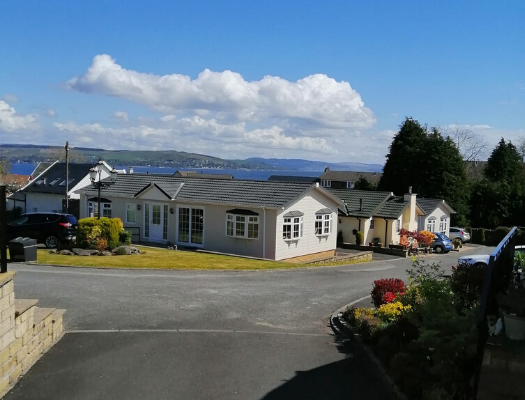
Photo 1: Today’s wee virtual tour takes us to Hunter’s Quay – what beautiful view and a massive blue sky! Not a bad place to be on lockdown we think – thanks to one of our Facebook followers for sending in this great shot. We’re seeing some converted caravans set right near the beautiful coast. Hunter’s Quay overlooks the Holy Loch and is located just outside the town of Dunoon. Hunter’s Quay takes its name from a stone pier built by Robert Hunter in 1828. The presence of a pier encouraged the development of large Victorian villas along the shore. Once a retreat for wealthy Glaswegians, today the area remains a tourist destination with a modern holiday village. Its pier is the base of a ferry line running to McInroy’s Point, Gourock.
Photo 2: There are still some architectural gems dating back to the area’s 19th century tourism boom, such as the B-listed Royal Clyde Yacht Club, now the Royal Marine Hotel. It was designed by Glaswegian architect Thomas Lennox Watson in the style of a Tudor Hall. Features of the Tudor style that can be seen on the hotel include half-timbering and steeply pitched gabled roofs. This impressive building is prominently located opposite the pier at Hunter’s Quay, making it one of the first things people see when exiting the ferry.
Photo 3: Another architectural gem that has stood the test of time and exemplifies 19th century extravagance is the B-listed Hafton House. The building was originally constructed in the late 18th century, but was redesigned in the early-mid 19th century. At this time, architect David Hamilton transformed the house into its current form: a Tudor Gothic mansion. Tudor elements that can be seen on this building include the multi-paned, slender windows and the elongated stone chimneys. A Gothic element that can be seen on this building is the crenallations. David Hamilton is also known for designing the Glasgow Royal Exchange, now the Glasgow Gallery of Modern Art.
#WhatsOotMaWindae 38: Biggar, South Lanarkshire

From the photographer:
Love your What’s Oot your Windae idea. Here are some pics from my windaes in Biggar. I’m fortunate to be somewhat surrounded by heritage.
Photo 1: Cadger’s Brig, an old packhorse bridge over the Biggar Burn. Local legend says that William Wallace dressed up as a pedlar (cadger) and crossed the bridge to spy on the enemy English camp, thus the name Cadger’s Brig. The house on the right was previously a brewery, and before that a mill with an undershot water wheel. This was later replaced with an overshot mill further up the burn.
Photo 2: Biggar Gas Works, now a museum owned by Historic Environment Scotland, honouring Scotland’s last surviving small town gas works. It is normally open to the public on summer afternoons. A hidden gem for industrial history buffs! My garden must have been hooching when it was operating – it stopped running in the 1970s and you can still smell the sulphur in parts of the works!
Photo 3: Burnside Cottages – former weaver’s cottages. The large downstairs windows were to provide light for hand weavers to work by. The deeds of my house record part of the land as Bleaching House Green, so I guess the woven cloth was brought down to the burn here to be washed and bleached. I guess that must have been before the Gas Works was built or the cloth would have ended up rather smelly!
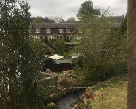
#WhatsOotMaWindae 37: Annan, Dumfries & Galloway
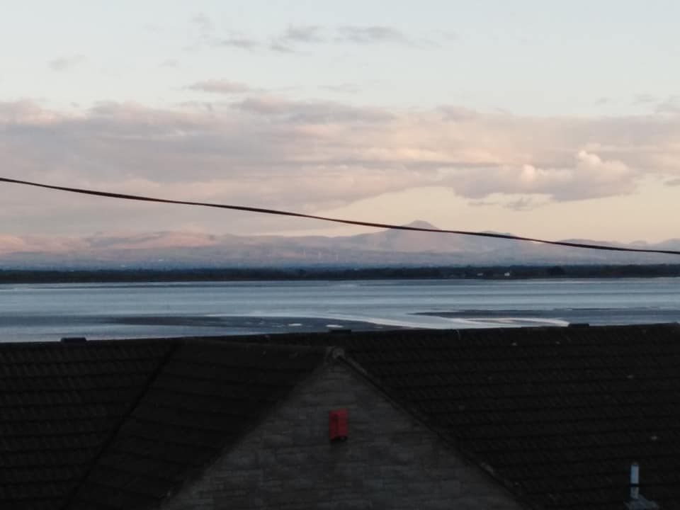
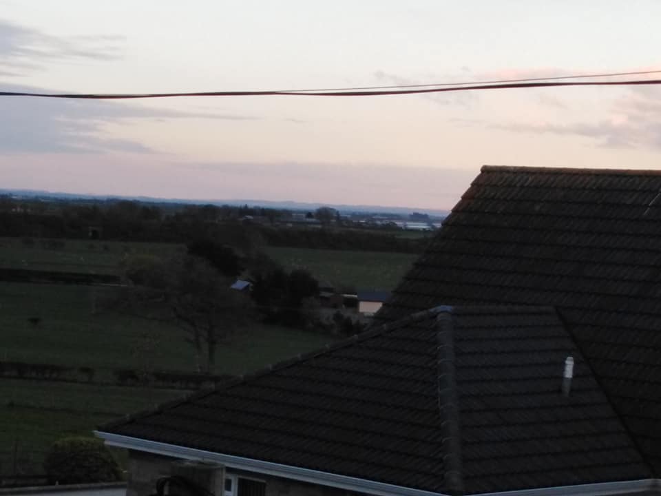
From the photographer:
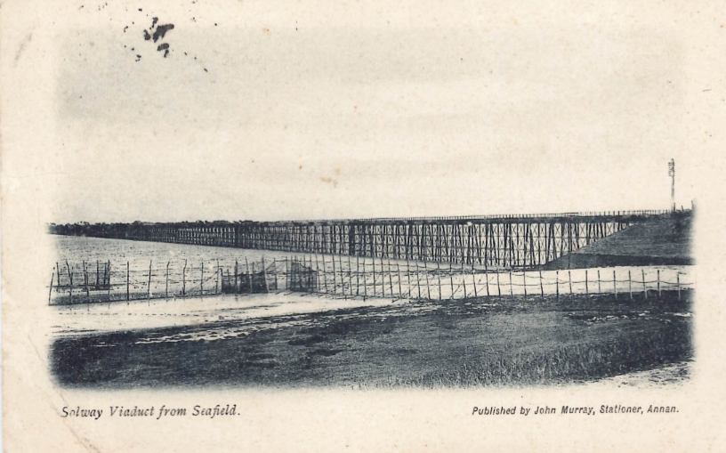
Photos 1 & 2: I live at Back of the Hill, Annan in Dumfries and Galloway and my house looks out over the Solway Firth. From my window, you can see the Lake District and the ebbing and flowing of the estuary tides and its shifting sands. About a mile from my house there used to be a viaduct which connected Scotland and England (or Annan and Carlisle to be more specific). All that now remains is the embankment that runs into the Solway and ends abruptly (the railway line was operational from 1869 until 1921). You can walk down it and there is an information board with its history at the end including the time it was damaged by ice flows in the Solway (this is difficult to imagine now!).
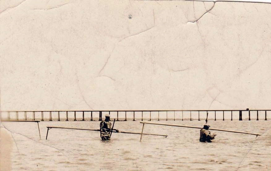
Photos 3 & 4: I work at The Devil’s Porridge Museum, about eight miles away. Our Museum tells the story of HM Factory Gretna, the largest munitions factory on Earth in World War One (it is also located on the shores of the Solway). The aforementioned Solway viaduct was used in World War One to transport workers and equipment to build and operate the Factory and we know of at least one factory worker who drowned after a failed attempt to walk across the viaduct. I’ve included an old photo of the viaduct from the museum’s collections! Our current exhibition in the Museum focuses on haaf net fishing, an ancient practice which is unique to the Solway and which usually begins to take place at this time of year in the view from my window too. I’ve also added an old photo of the haaf net fishermen, also from the museum’s collections.
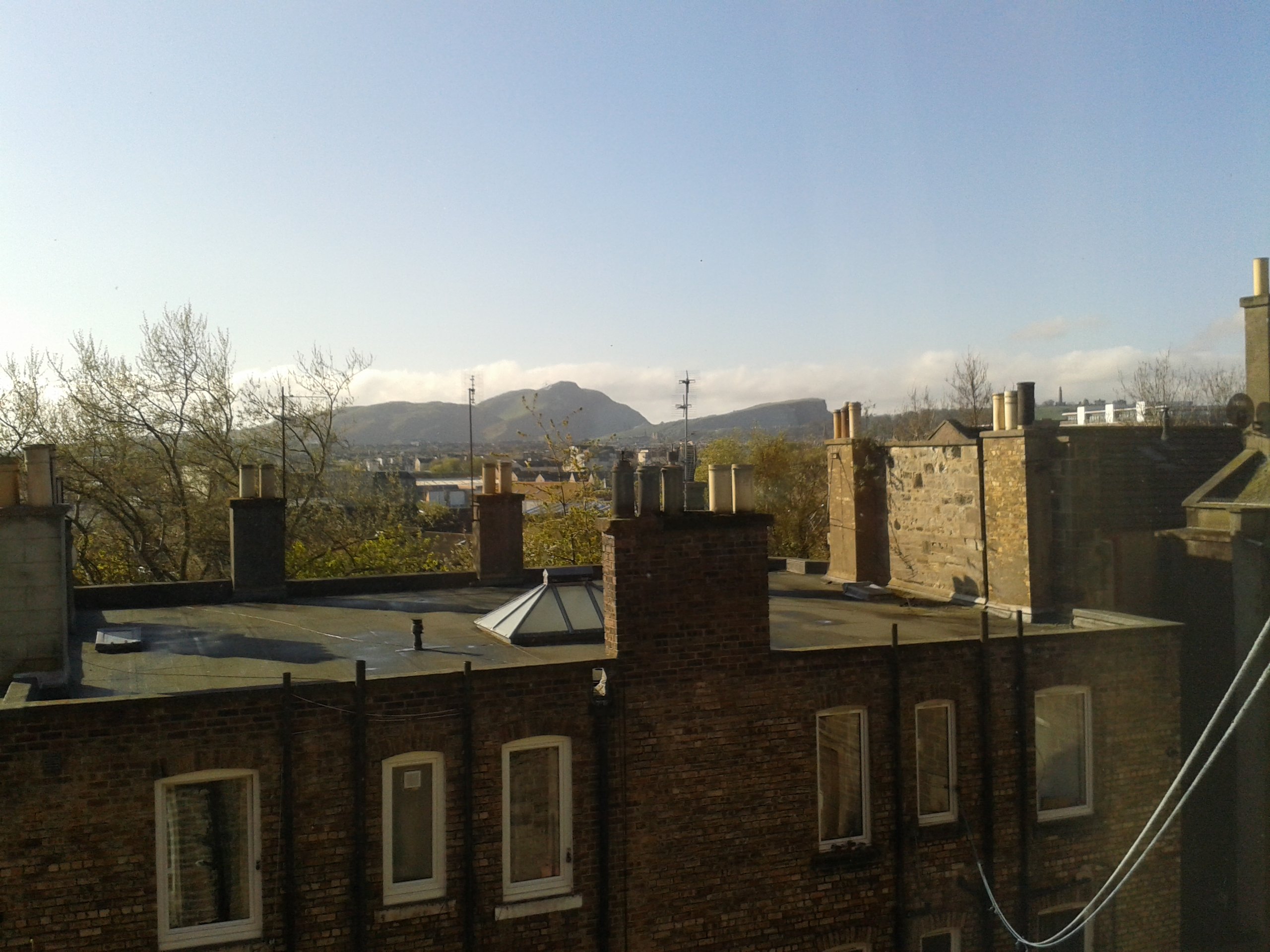
#WhatsOotMaWindae 36: Perth
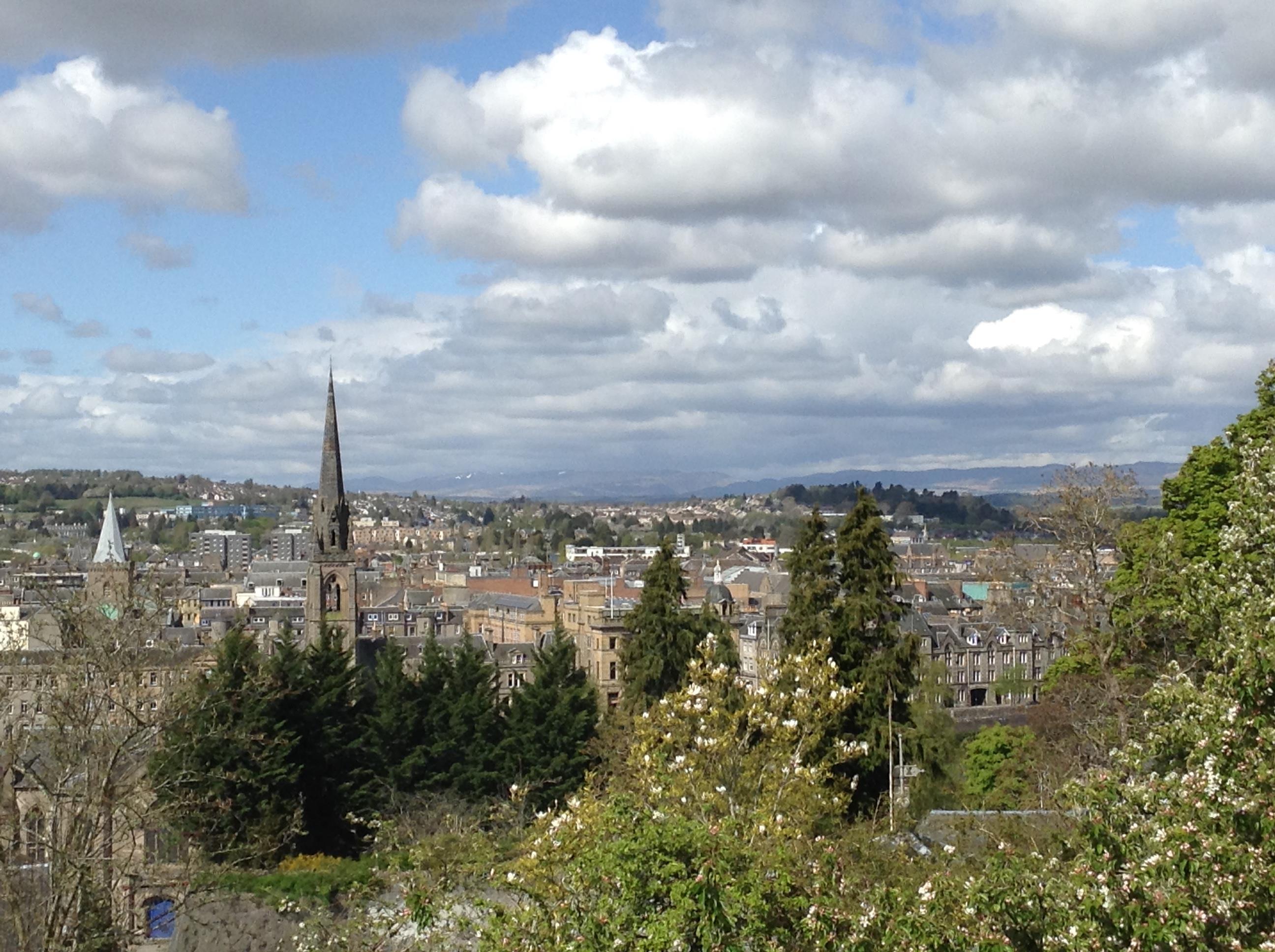
From the photographer (describing photo 1):
From my study I have a fine view over Perth and with super keen eyesight you can maybe just make out St Ninian’s cathedral (Perth Cathedral) on the right? It’s just above and a bit to the left of the green roof of Perth Concert Hall – you may be able to spot the gold flèche above the bell? The cathedral’s architect William Butterfield designed the building with two towers at the West end, but apparently during construction these began to subside and were replaced with a single tower…which also went wonky. So now the gold flèche is the identifying feature!
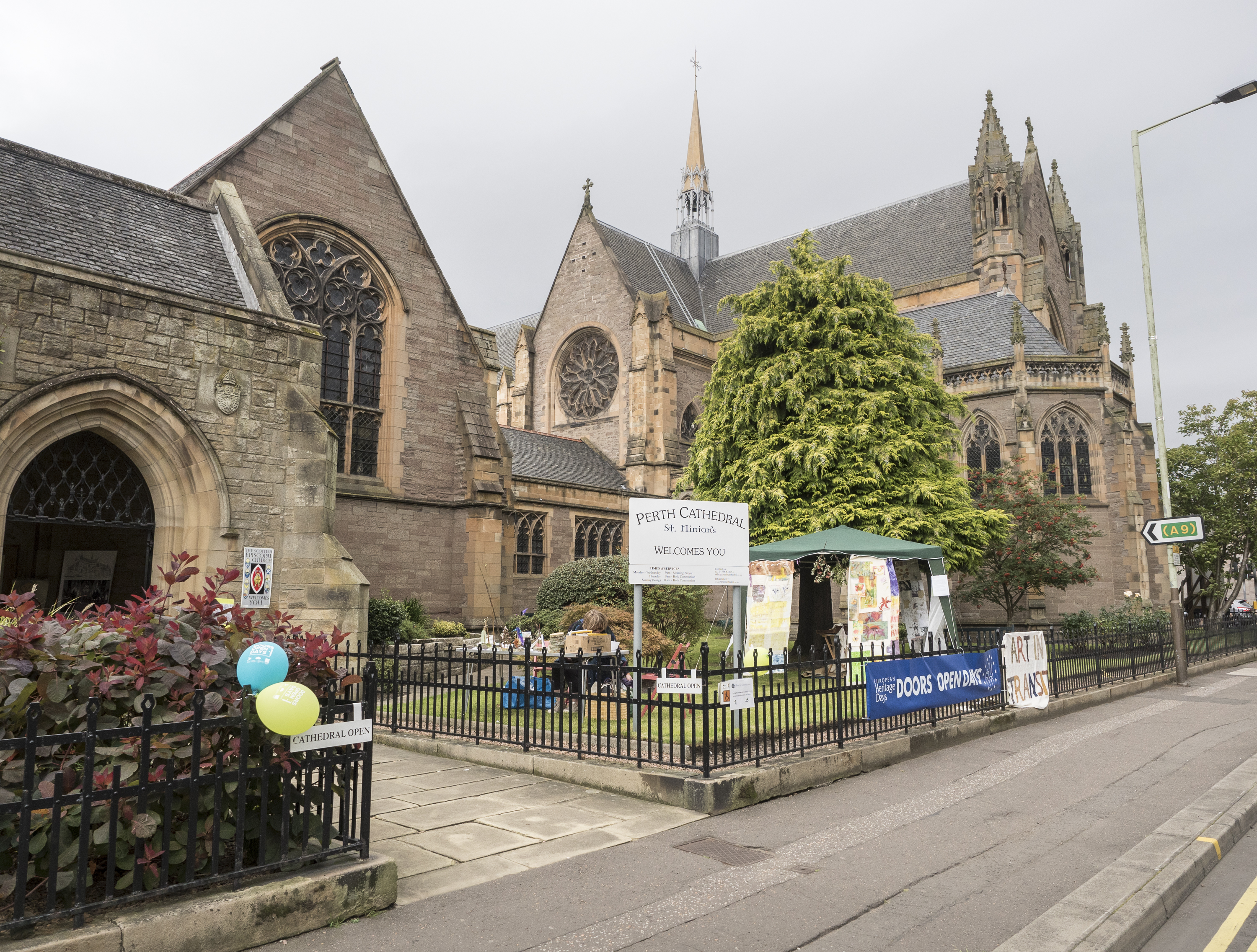
Photo 2: We’ve added a wee shot of St. Ninian’s from Doors Open Days 2019 so you can see the gold fleche that the photographer has mentioned. Did you know that St Ninian’s Cathedral was consecrated in 1850, becoming the first cathedral to be built in Britain since the Reformation!
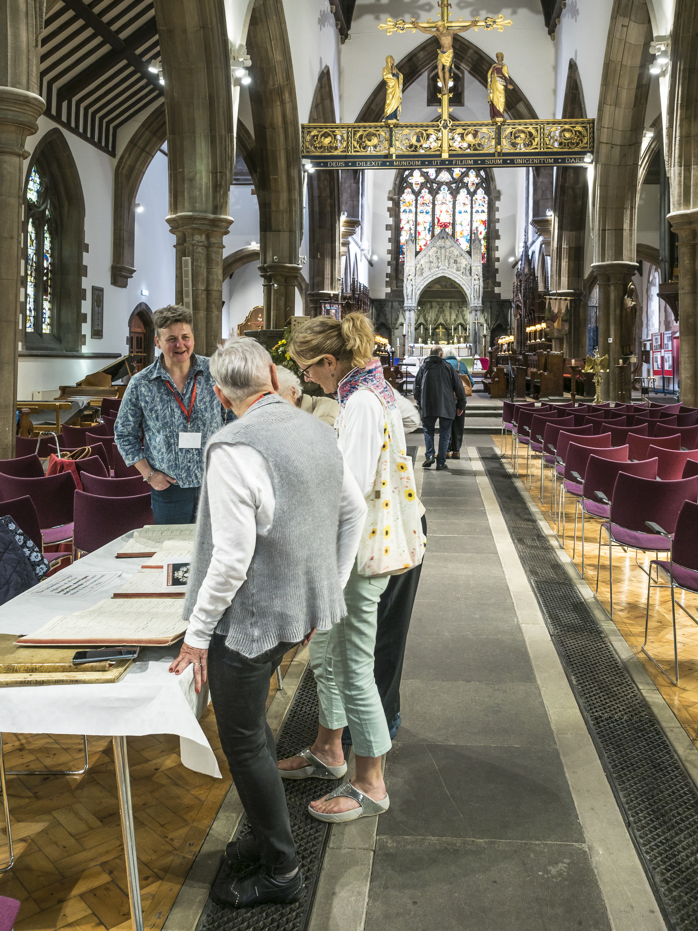
Photo 3: The Cathedral also has some exceptionally fine interior components, which you can see from the interior picture we’ve added from Doors Open Days 2019. An interior feature we’d like to highlight is the quatrefoil-plan piers. “Quatrefoil-plan piers” are piers with cross-sections in the shape of a quatrefoil. A Quatrefoil is a symmetrical shape formed from the overall outline of four partially overlapping, congruent circles. The associations with the shape are constantly shifting depending on where it’s used, who is using it, and what purpose it is used for. But overall, the symbol implies “fanciness”, which art historians suggest is because it’s geometrically precise, and thus requires skilled labour to create. Read more about the fascinating history of the quatrefoil here!
#WhatsOotMaWindae 35: Dalkeith, Midlothian
From the photographer:
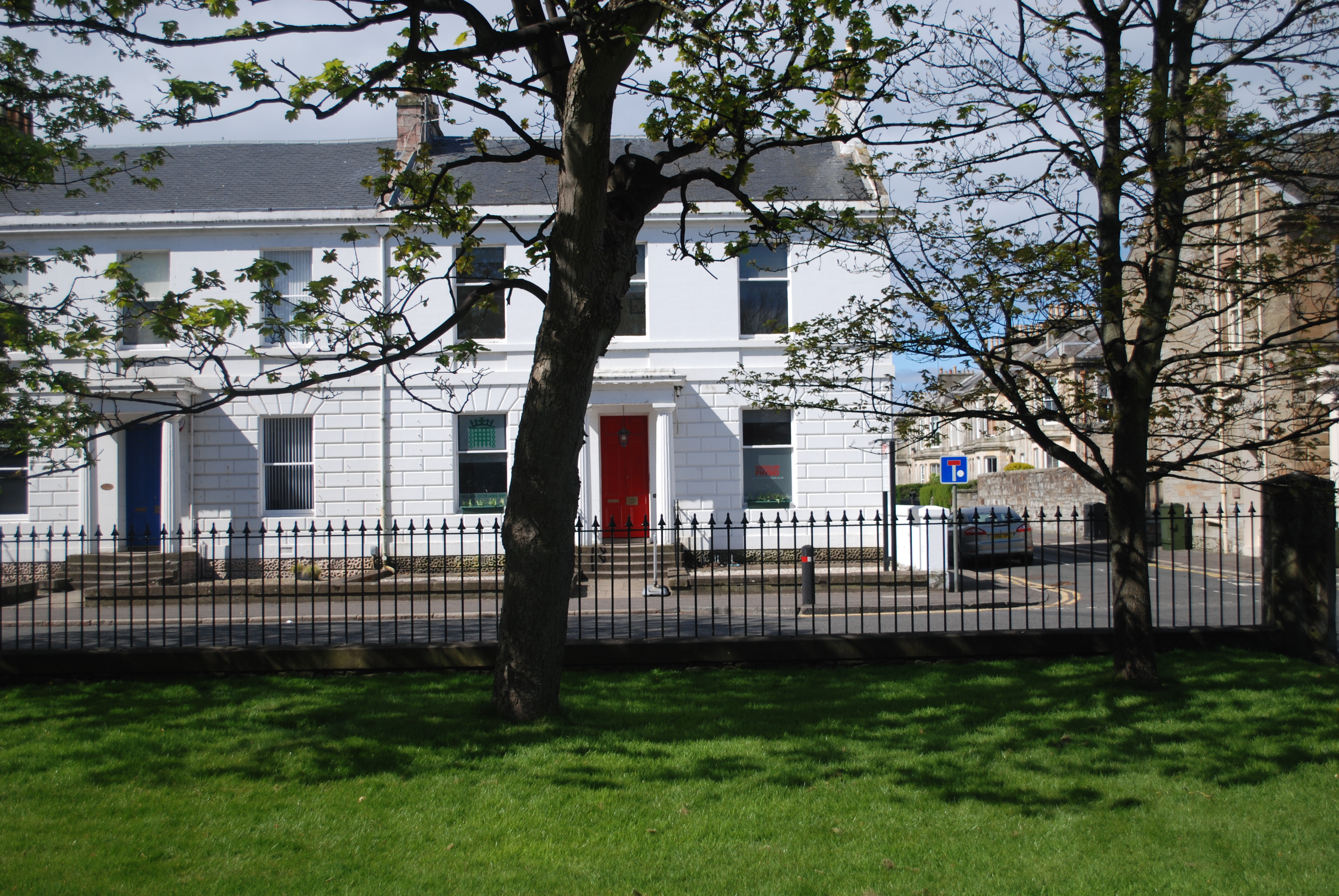
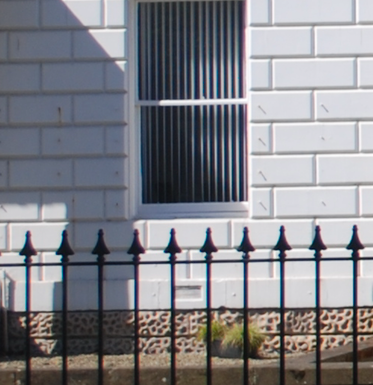
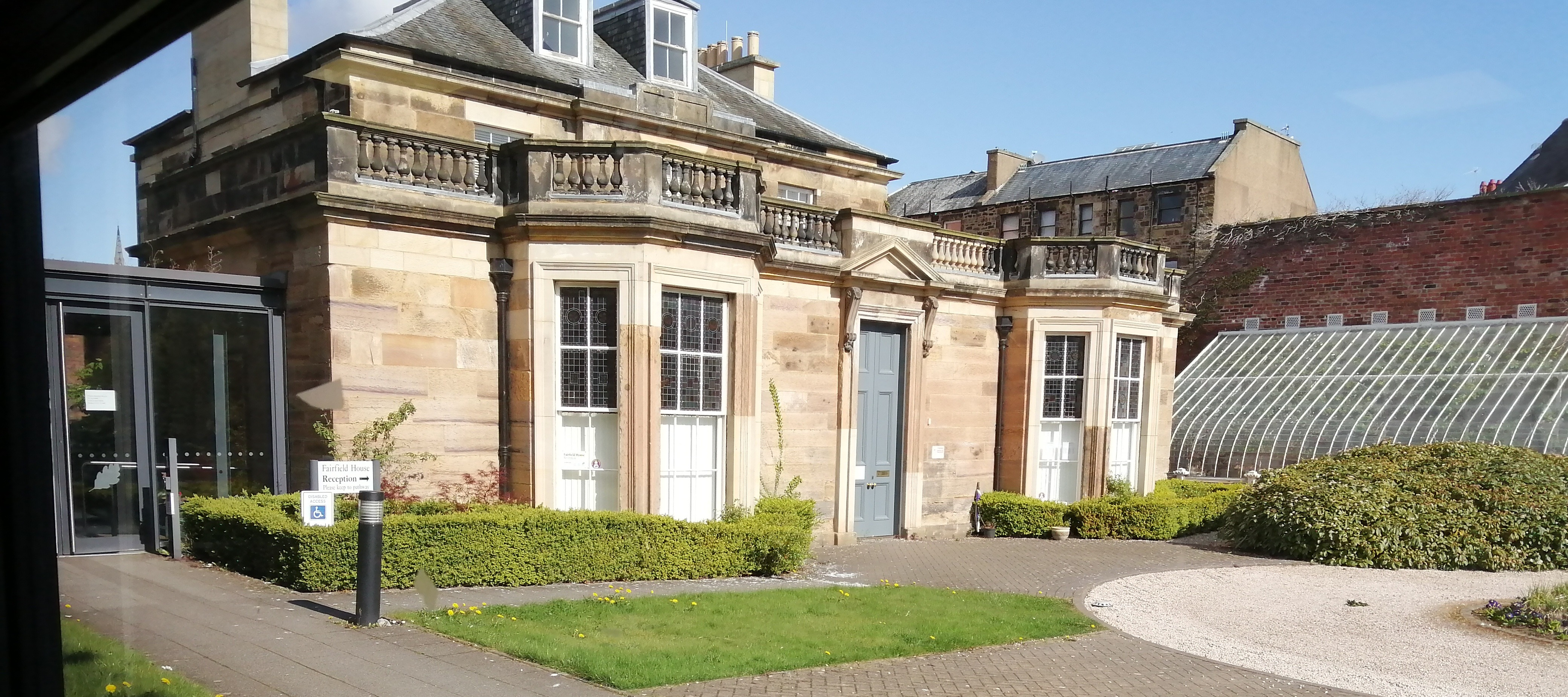
Fairfield House is an early 19th century classical villa with an 1840 extension containing original period stained glass. The villa was derelict for a period, but has now been restored to its former glory by Midlothian Council. The building now forms part of a modern office complex designed by Michael Laird Partnership – the old and new buildings have been linked by a glazed entrance hall. The new building is of a low-energy design. Its form and orientation maximises the use of daylight and controllable natural ventilation. A sculpted frame of exposed concrete allows the heat generated by windows to cool naturally, while ventilation systems are used to regulate heat. The building even won the Civic Trust Award in 1999 for a contribution to the quality and appearance of the environment.
A smashing shot of a B-listed building, Fairfield House, in Dalkeith! Looking at the front of the building, we are loving the elegant symmetry of the original villa – two bay windows, two dormers and two wall head chimneys that beautifully mirror each other. We particularly like that the dormers have slate cheeks, meaning that the sides of the dormers are covered in slate, like the roof. This shows such a great attention to detail. To the side of the house (seen on the righthand side of the shot), there is an A-listed hot house, added to the property in the mid-19th century. The hot house is still in use today, with an interesting international connection. Sources suggest that following the recent restoration, a vine from Dalkeith’s twin town of Jarnac in France was planted in the hot house.
#WhatsOotMaWindae 35: Scottish Borders
Now for a trek to the Borders and this gorgeous terrace of houses. What we adore about this first off is the chimney stacks! These are some beautiful party wall stacks and wall head stacks – they are so striking and dominate the terrace, giving the street wonderful symmetry. Party wall stacks are chimneys atop party walls, which are dividing walls between two adjoining buildings that are shared by the occupants of each building. Wall head chimneys are built on top of the front and back walls of a tenement.
Did you notice the lack of roof clutter such as redundant aerials and satellite dishes? This really helps enhance the roof line and historical context of this terrace. Did you also notice the wee roof detail behind the front wall stacks, tying back into the main roof? You don’t see this too often and it is just wonderful attention to detail and design. Each house also has a beautiful slate roof and gorgeous stone detailing around both the windows and the doors. The bay windows with delicate roof detailing tying back to the main roof is just lovely. And do we see lovely cast iron rainwater goods including dinky hopper heads (the containers at the top of a vertical pipe which receives water from a gutter)? One final detail worth noting is the consistency of the window design, one pane over one pane. It is hard to make out what is timber versus what is plastic, but this consistency in fenestration again give the street great consistency.
#WhatsOotMaWindae 34: Westercraigs, Glasgow
From the photographers, Dennistoun Conservation Society:
This is a view from the top of Westercraigs looking down to King’s Cross (Duke Street and Bellgrove junction). The first occupant of this house, Reverend Rattray, in 1874, would have had this view as all the villas were here prior to that date.
What a wonderful street adorned with such incredible Victorian villas! This street is within the Dennistoun Conservation Area – a conservation area is defined as being of “special architectural or historic interest, the character or appearance of which it is desirable to preserve or enhance”. As we mentioned way back in our first #WhatsOotMaWindae, Alexander Dennistoun employed the famous architect, James Salmon in 1854 to plan out Dennistoun. The scheme was much grander than what we have today, but nonetheless, some of the wonderful villas and terraced streets remain today, including the villas in this shot! Toward the end of the street you can just make out (what remains of) Blackfriars Church, built around 1876, but which has been converted into flats in recent years. The Dennistoun Conservation Society has had an enquiry about what happened to the set of five bells from Blackfriars Church tower when it was converted into flats. They were one of the few complete sets cast by Gorbals Bell and Brass Foundry. Do you have any leads about the missing bells? If so, get in touch with Dennistoun Conservation Society.
#WhatsOotMaWindae 33: Musselburgh, East Lothian
From the photographers, Musselburgh Conservation Society:
This is our view from Hope Place, Levenhall, Musselburgh. It shows the back of the local pub The Levenhall Arms, and on the left a terrace of artisans red sandstone cottages. In the background you can see some red brick flats built about 30 years ago.
This is a great picture showing varied building types. From right to left you are getting an old rubble wall (made of stones which are undressed and not uniform in size) which was raised with new build, the strong gabled public house straight ahead and the ridgeline of the red sandstone cottages that the photographer mentions. On the public house, you can just make out the sash window on the top left – notice how the glass seems to distort the reflections? This to us suggests original plate glass which has wonderful texture and plays with the light beautifully! For more on the repair and maintenance of historic windows and doors, you can check out this resource from the SPAB (the Society for the Protection of Ancient Buildings). Lastly, we are also full of admiration for the striking pantile roof on the pub. Pantiles are clay roof tiles that are S-shaped. They are laid in rows so that the bottom of one tile overlaps the top of the tile below. The S-shape of the tiles helps with drainage by directing rainwater into the centre of the tile and channeling it down the roof slope.
Though we are unable to see much of the aforementioned cottages on the lefthand side of the shot, we do like the dinky wee dormer saying hello and the very steep pitch of the roof – was this once thatched? Could some local historians drop us a line? Finally, the wee boundary wall of the cottages is ever so sweet the way it both undulates and works with the curve of the street.
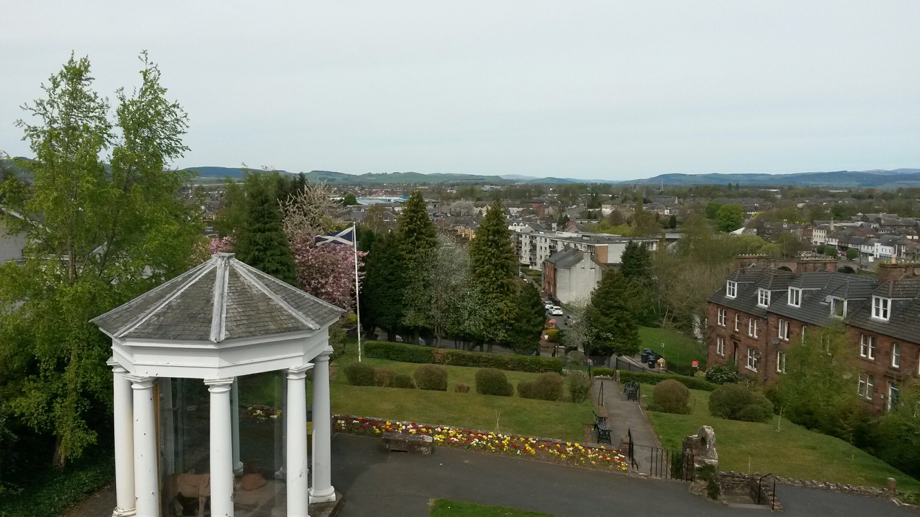
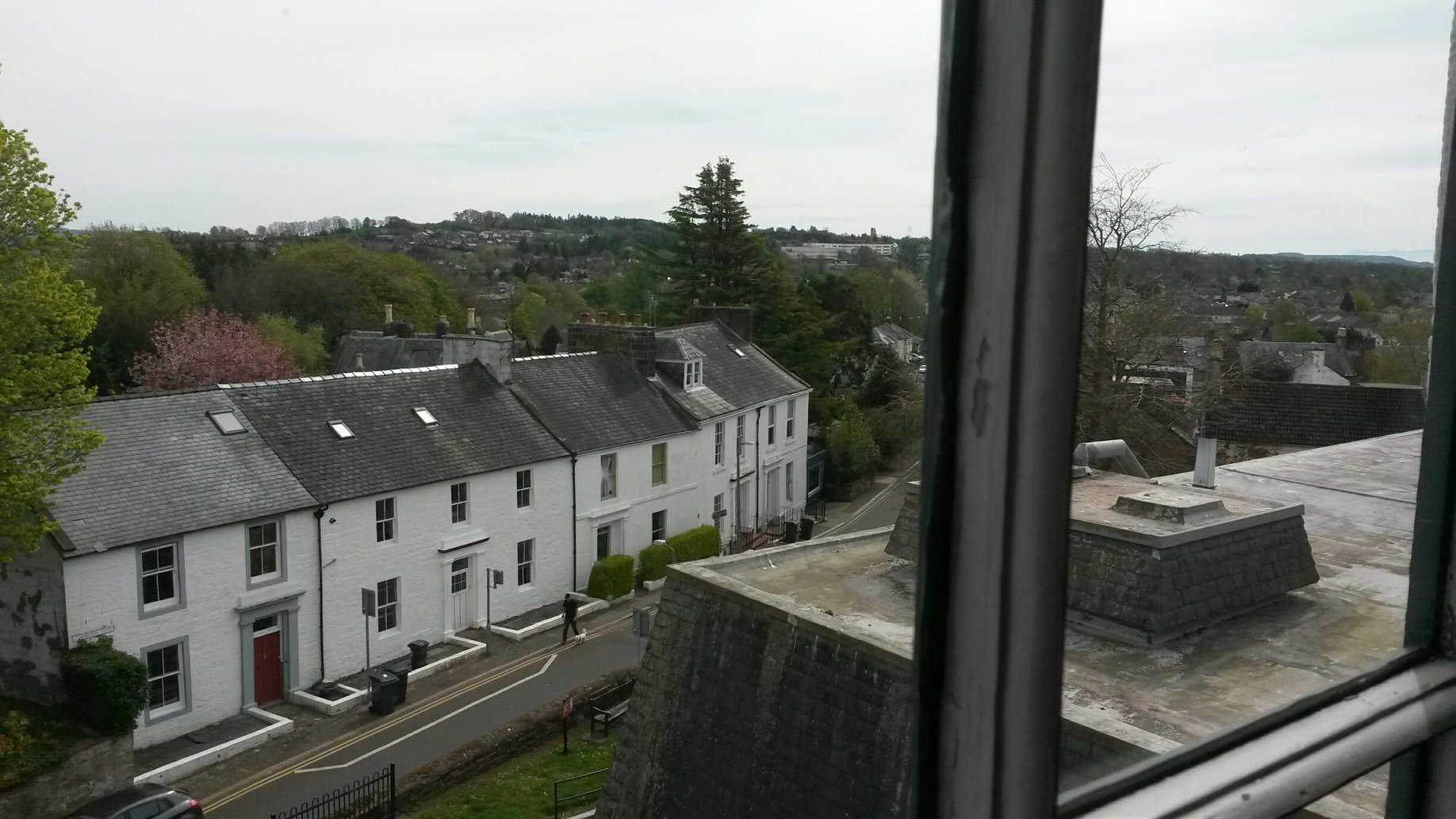
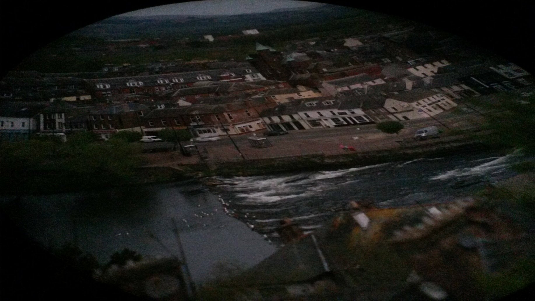
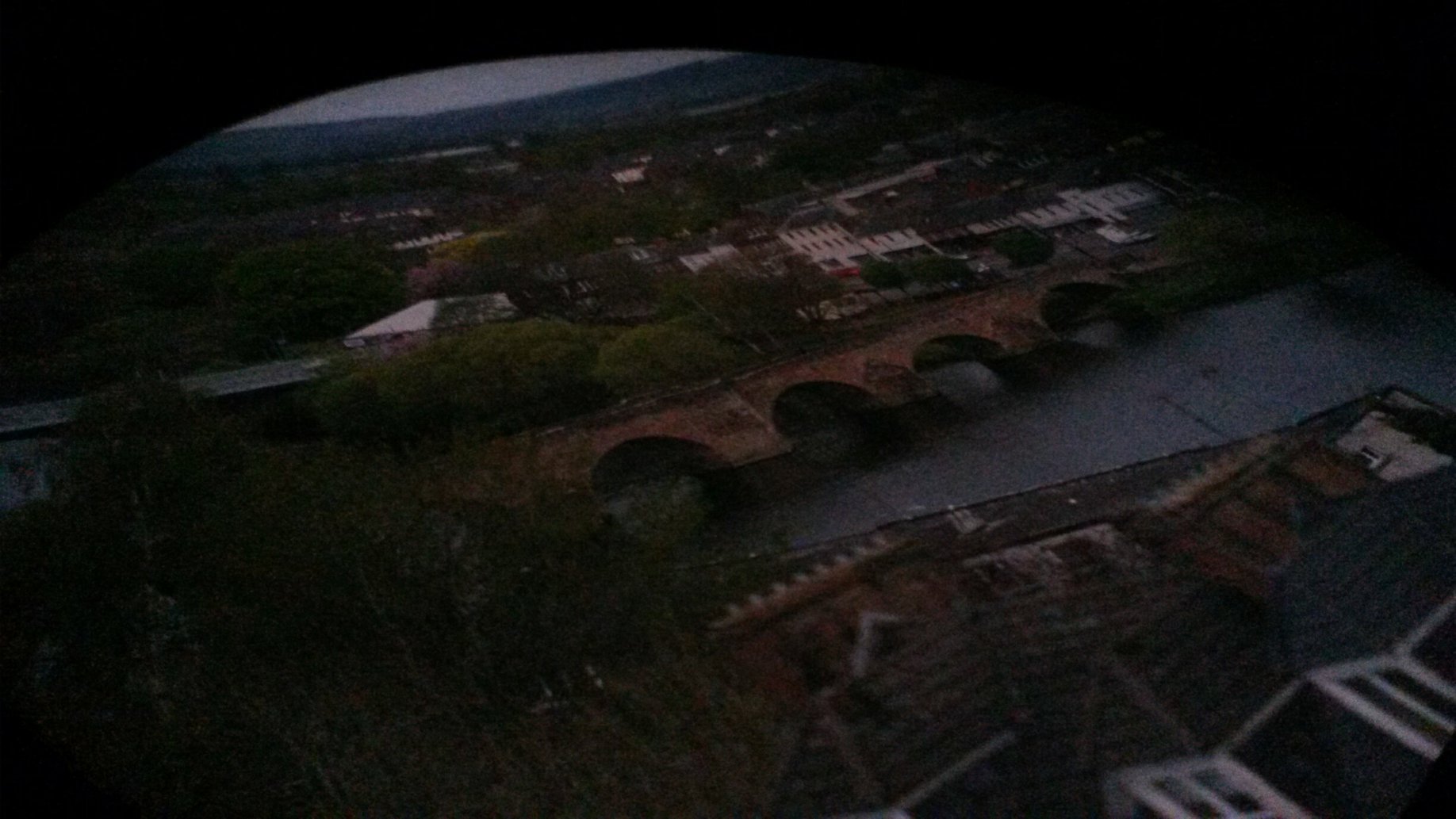
#WhatsOotMaWindae 32: Dumfries Museum, Dumfries & Galloway
From the photographers:
Here are some views from the windmill tower at Dumfries Museum (photos 1-2) including a sneaky peak at the view of town provided by the oldest working Camera Obscura in the world (photos 3-4). The Camera Obscura is on the top floor of the windmill tower at Dumfries Museum. Originally an astronomical instrument, it was installed in 1836 when the windmill was converted into an observatory. From it you can see a fascinating panoramic view of Dumfries and the surrounding countryside.
Thanks for sending these shots in – lots of architectural gems here! The lovey wee temple we can see in photo 1 is B-listed (1841). It’s an open octagonal painted stone Tuscan temple, one bay of peristyle (row of columns that surrounds a building). With a low-pitched and facetted roof (a roof with multiple sides). So lovely!
Photo 2: This terrace of houses are all B-listed as well. As per the Historic Environment Scotland listing:
- They are an early-mid 19th century, 2-storey terrace (a row of houses joined together along their side walls) of 5 houses.
- Number 4 differentiates itself from the others with a single dormer (windows typically set vertically on a sloping roof).
- Numbers 1 and 2 are rubble-built (the stones are undressed and not uniform in size) with ashlar dressings (dressing is a general term for all finishes or mouldings, often projecting, around doors and windows)
- Number 3 has a band course (A horizontal, decorative row of stonework that extends across the front of a building) between floors.
- Each house has pilastered doorcase (a pilaster is a decorative rectangular column that projects partially from the wall to which it attached) with recessed door with fanlight.
#WhatsOotMaWindae 31: Inverness
Heading up to Inverness now and we are loving these beautiful blue skies! So, what can we see on these delightful houses?
Photo 1: those ridge tiles (tiles that run across the ridge of a roof) are so sweet atop the lovely lefthand slate roof. On the righthand building, we’re admiring that well-pointed chimney stack. We’re also appreciating the deep eaves (the part of a roof that meets or overhangs the walls of a building) on the righthand building – they look like well-fitted hats! We’re spying some cast iron rhones (half-round gutters) on the righthand building as well. Lastly, the segmental wall dormers (a dormer whose front wall is in line with the wall below, like a continuation of the wall above the roof eaves) are just too cute!
Photo 2: Hipped roof, meet gabled roof. This is a lovely contrast when you look straight-on. Is the house on the right getting some new lime pointing we wonder? Lime mortar needs regular maintenance in the form of re-pointing every few years. This is because lime mortar is “sacrificial” – the mortar is softer than the stone, so if the wall gets wet water will drain through the mortar; this means that the mortar will break down over time, but in doing so saves the stone. Also, the wee finial up top is so pretty as is the brattishing detail (a decorative cresting that often includes leaves or flower motifs) just above the ground floor bay window. Great to see surviving ironwork details like this. **Top Tip**: If you are ever surveying a building, it’s always worth looking at the ridge line. If it is bowed slightly, it may give an indication that something within the roof needs closer inspection. However, the ridge lines on these buildings look super level and straight!
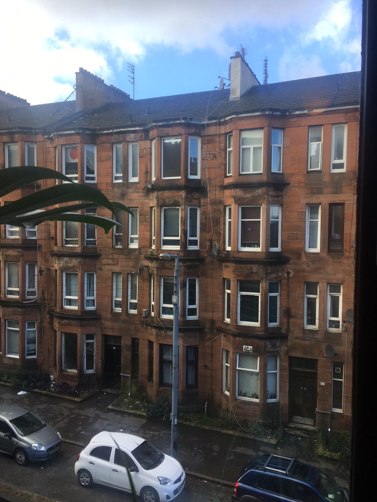
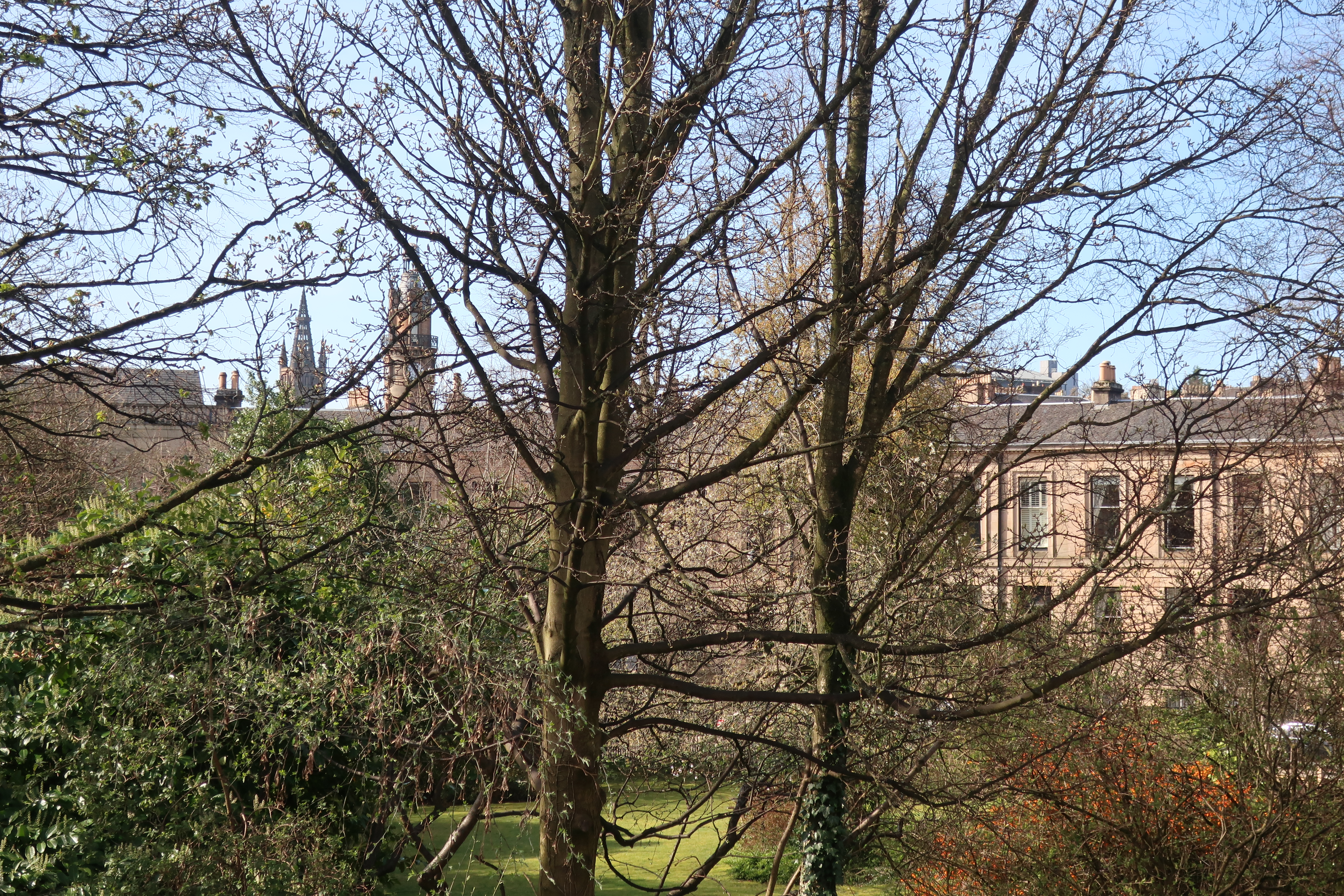
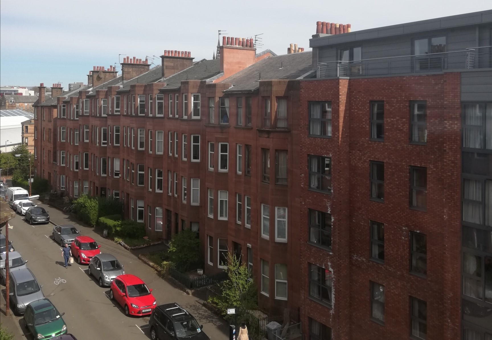
#WhatsOotMaWindae 30: Belmont Crescent, Glasgow
Wow! A B-listed curve of houses on Belmont Crescent AND the A-listed Glasgow University Gilbert Scott building peeking through the trees in this first shot…can we move here please? There are so many amazing architectural features on Belmont Crescent (we’ve included a front view of it for photo 2), so we’ll go through some of the Historic Environment Scotland listing and break it down for you:
- Astylar (lacking columns as a decorative feature), terraced (belonging to a row of houses joined together along their side walls) crescent of 16 houses.
- 2 storeys over basement, with steps oversailing (part of a building projecting over a lower part) basement to tall doorpieces.
- All upper windows are architraved (the windows are framed by moulding).
- Band course (A horizontal, decorative row of stonework that extends across the front of a building) at upper floor window cills.
- Decorative cast-iron railings to steps and basement.
An interesting feature of Belmont Crescent is the central ‘pavilion’, a taller section in the middle of the terrace, used to give variety and focus to the curve of the crescent. This central pavilion is 9-bay (bays are the number of windows in a horizontal line across a facade) and 3-storeys over the basement. Hopefully we’ve helped cut through the technical architectural terms a bit. Now when you see those terms, you’ll be in-the-know!
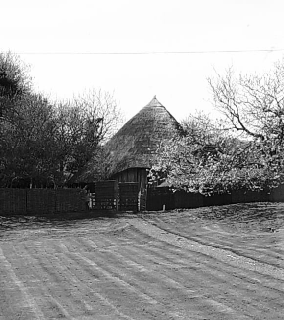
#WhatsOotMaWindae 29: Whithorn Roundhouse, Dumfries & Galloway
This reconstruction of an Iron Age roundhouse is just the most wonderful view. Here’s a bit about some of the roundhouse’s details, and how the roundhouse came to be, from our friends at the Whithorn Trust and AOC archaeology:
The Iron Age roundhouse at the Whithorn Trust was built in 2016, for opening to the public in Spring 2017. It was built on precise details derived from excavations by AOC Archaeology at Black Loch of Myrton, which began in 2015 and continue seasonally. The settlement there dates to approximately 450BC and includes some of the best preserved evidence ever found for Iron Age woodwork, which survived well in the boggy, waterlogged conditions. Waterlogged conditions preserve wood because the lack of oxygen in the soil slows the natural process of decay. Over the years, the excavations have uncovered: an oak doorway; a façade of vertical oak timbers; woven flooring made of hazel, covered with grasses and vegetation; evidence of wood-turning and metalworking; and a finely decorated wooden bowl.
The Whithorn Trust has used the evidence to construct this full-size replica, which won the Scottish Heritage Angels Award in 2017. It measures 13 metres across, with a central working fireplace, and is about 9 metres at the apex. The building is thatched with water reed – this work was carried out by local volunteers and trainees, under supervision of a master thatcher. The timbers are alder or oak and the woven walls, filled with clay, are from hazel gathered from an Atlantic Hazel Woodland near Newton Stewart. The Trust now operates the venue as part of its visitor attraction and for educational and community use. The interiors of the building continue to develop, as archaeologists continue excavation and post excavation analysis.
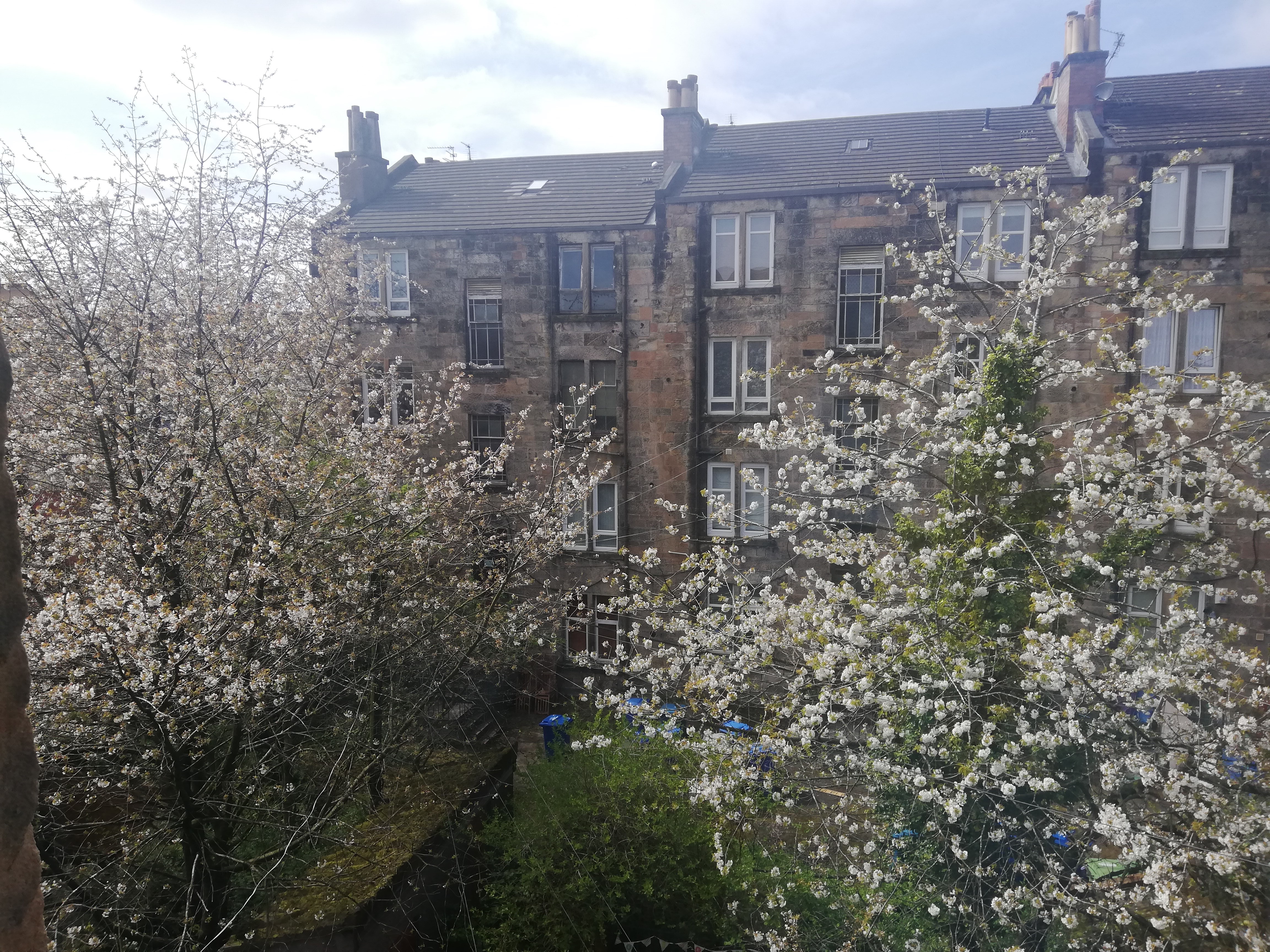
#WhatsOotMaWindae 28: Yorkhill, Glasgow
Photo 1: what a great row of tenements and we just love the way they subtly step down with the gradient of the street. Can you see how the bay windows on the tenements project upward creating a wee parapet? So sweet! Also, notice the missing metalwork on the remaining entryways. This is either a result of deterioration or damage of the metalwork, or because the ironwork was taken away to support the war effort. Lots of clues can still remain though to help determine the style of ironwork that was once there, such as the spacing of the holes, the shape of the holes and any remaining pieces of metalwork… check behind those hedges! The new build in the foreground is interesting too in the way it respects the scale and colour of the existing tenements, with projecting windows and fenestration (arrangement of windows) that complement the existing tenement windows.
Photo 2: an amazingly blossom-filled picture! We encourage you to look at the rear elevation of buildings as you can often find some original features. This is because owners aren’t as likely to alter the backs of buildings, as they would generally not be seen. The stand out here for us is those stunning close/stairwell windows. It is great to see these original timber beauties with the coloured, surrounding edges of the glazed unit. These will flood the communal ways with such colour! There is, though, lots of staining around the rainwater goods which is a sign that something is not quite right. Worth taking a look (safely) in wet weather to ascertain leaks and a possible course of action! Finally, as above, loving the dinky little steps these tenements are taking down with the gradient.
#WhatsOotMaWindae 27: Leith, Edinburgh
Leith – a lovely wee place by the water, with lovely architecture, history and views! In the words of our friends at BT Architects (the photographers of this shot):
Leith is a mix of architecture from different periods and for a range of purposes, but in the foreground mostly chimneys. Mary Poppins style I can dream myself away to Arthurs Seat and Calton Hill while I work from home!
The star of the show here are these brick beauties! Who doesn’t love brick with its wonderful colour, size and texture variations? There are some beautiful, soft brick arches above the windows here (pity the timber windows are no more but hey ho…). We’re also really liking those very regimented chimney stacks that the photographers have mentioned. We did a little feature on chimneys in one of our previous posts (#7 Newington), as well as a feature on chimney pots (#18 Stirling) – so scroll down and check those out as well. Back to the shot from Leith – the pyramidal rooflight would allow natural light to flood the stairwell below. These rooflights are often found on historic buildings – they were popular architectural features during the Victorian period. We can also see two smaller rooflights to either side of the roof; originally these would have been cast iron. The flat roof is interesting as it forms a small parapet wall around the edge. A ‘parapet‘ is a low wall that extends upwards at the edge of a roof, terrace, balcony, walkway or other structure. Delicious!
#WhatsOotMaWindae 26: Heart of Neolithic Orkney
From the photographer:
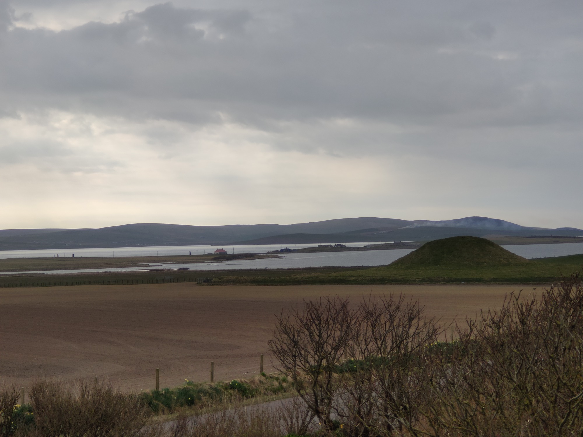
Attached is a photo taken just a couple of minutes ago (14 April) from my study window in my home. In the foreground is the neolithic tomb of Maeshowe, in the middle distance left are the Standing Stones of Stenness and middle distance right you might just make out the neolithic stone circle of the Ring of Brodgar. These are three of the four major sites making up the World Heritage Site of the “Heart of Neolithic Orkney“. My name is Keith Brown and have the privilege of working as an Historic Environment Scotland Ranger at these sites. It’s a hard life but someone has to do it!!
Firstly Keith, we are so jealous of your role in this incredible location – that’s 5,000 years of history oot yer windae! Does it get much better? We’ve done some *digging* into the history of Maeshowe and found a supernatural story we’d like to share. When Maeshowe was excavated in 1861 by James Farrer, local Orcadians told him that “the building [Maeshowe] was formerly inhabited by a person named Hogboy, possessing great strength”. Although no description of this Hogboy survives, we do know that ‘Hogboy’ is one of the names that locals have given to the spirits that are rumoured to haunt mounds across Orkney. These legends often kept people from excavating or disturbing mounds, in fear of upsetting the spirit within. You can read more about mound dweller folklore across Scotland here, with this great article from our friends at DigIt!
#WhatsOotMaWindae 25: Stornoway, Western Isles
This lovely picture came to us all the way from Stornoway! Dead ahead (had to use a nautical theme!) is a lovely hipped roof on show but what catches us here is the available green space and sense of openness in this picture. Fitting for today’s post, in honour of Earth Day 2020! Also, is that a modern interpretation of a catslide roof in the far left? A catslide roof is a roof that continues down below the main eaves height and allows you to have a greater depth of building without increasing your ridge height.
Now, let’s look to the right at this wooden house that just sticks a bit into the shot? The photographer has shared with us that they think it came from Scandinavia and was reassembled in Stornoway! What a wonderful thought. It is a delicious wee house with that strong gabled roof and of timber construction, which would allow for very quick assembly. Timber is one of the most sustainable building materials – firstly, it is a renewable resource, meaning that harvested trees can be replaced by planting new ones. Also, timber requires little energy to transform it from the raw material (living tree) into timber for building. Timber can be even more sustainable when it is sourced locally, as this decreases the energy used to transport materials to the construction site. You can read more here to learn how timber can be sustainably-sourced! For all of these reasons and more, timber is popular in Scottish construction as a key way to address the Climate Crisis and reduce our carbon footprint. This wee timber house also provides a nice aesthetic contrast amongst its masonry contemporaries too. Did you also notice that there is no chimney stack protruding from the roof (that we can see); how interesting!
#WhatsOotMaWindae 24: Stewart’s Melville College, Edinburgh
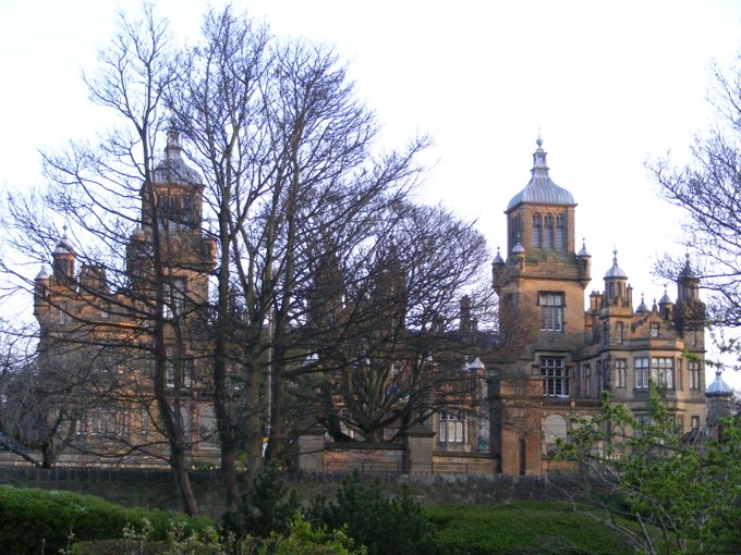
Wow! Here we have the A-listed, incredibly beautiful Stewart’s Melville College in Edinburgh. An extensive Neo-Jacobethan college building with a wonderful separate Art Hall. Scotland’s own Sir Basil Spence worked on some of the interior decoration! There is so much to mention about this building so we’ll just mention a few of the lovely architectural features.
As per Historic Environment Scotland, this building is a 16-bay (bays are the number of windows in a horizontal line across a facade), 2-storey (front courtyard now enclosed) Neo-Jacobethan college building. Examples of this style are Harlaxton Manor in Lincolnshire, Mentmore Towers in Buckinghamshire and Sandringham House in Norfolk, England. In the neo-Jacobethan style, lots of detailed ornamentation is common, usually designed by one architect. In the case of the Stewart’s Melville College, David Rhind (Edinburgh-born) designed the main college blocks.
.jpg)
Some details we’re loving are the turreted towers at the corner of the flanking bays. These towers, with crenellated 3rd stage and octagonal 4th stage, culminate at the top with ogee dome. Ogee domes are domes with a pointed apex, formed by the intersection of two S curves. You can also see ogee domes on the larger turrets! There are also moulded architraved windows, some hoodmoulded, transomed and mullioned. There is predominantly plate glass in timber sash and case windows.
Phew! Today’s home schooling homework is working out these architectural terms!
#WhatsOotMaWindae 23: A secret garden in Edinburgh’s Old Town
Now this is where we need to be during lockdown, immersed in lovely nature. We’re going to do a ‘spot the building features’ with this one! So, what do we see…on the house to the left we have sash windows, which are a wonderful 6 x 6 design. ‘Sash windows‘ are made of one or more moveable panels, called ‘sashes’. These sashes form a frame that holds panes of glasses. Sash windows often have two panels that open by sliding up and down or sliding side to side. This is different from casement windows, which open by swinging outwards. We’re also seeing solid stone window surrounds too. The lower windows are what are called tripartite windows, which means three-part windows – you can see one large opening with two smaller openings on each side. This is a classic detail usually found in higher status buildings. We also spy a lovely hipped roof through the trees! It’s also great to see original cast iron pipework – we love original building details! Good maintenance is where it’s at!
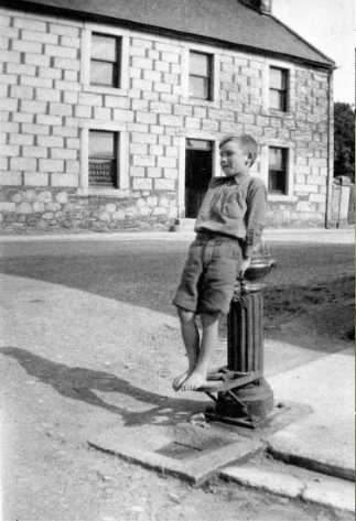
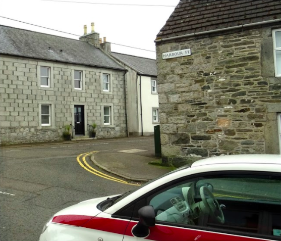
#WhatsOotMaWindae 22: Creetown, Dumfries & Galloway
From the photographer – Mick Macleod, Dumfries & Galloway Doors Open Days Coordinator: On the left, we can see Harbour Street 100 Years ago. The young boy, William McKie straddles the Water Standpipe on the corner of the street. On the right, we can see the view fom my office window in 1 Harbour Street today. William McKie went on to work in the Creetown Co-Op store from this room.
This is a great set of pictures that subtly show change over time. We’re loving the road surface in the original picture! There is a lot going on here so let’s pick out a few bits. Creetown is a coastal town on the west coast, note the Harbour Street street name? The older building in the picture is interesting as it was once a draper store (it sold textiles). The building has an exciting historical juxtaposition of stone – the lower ‘courses’ (a layer of stone running horizontally in a wall) of stone are very rough and of rubble construction, transitioning to neatly cut stone above. We wonder – maybe these are the foundations of an earlier building? The wee ‘pinning’ stones (small stones embedded in the wall to make larger stones secure. This was common practice in traditional rubble stone masonry walls) are most interesting. The pinning stones almost resembles ‘Aberdeen Bond’ which was three wee pinnings between the main stones. Also if these are the original windows, that’s amazing!! (shame the wee pump is gone though). There are some roughly hewn granite quoins (stones at the corner of a wall – can be structural and/or for decoration!) just below the Harbour Street sign and a lovely palette of rubble stone built walls. We’re loving the big, chunky window surrounds!
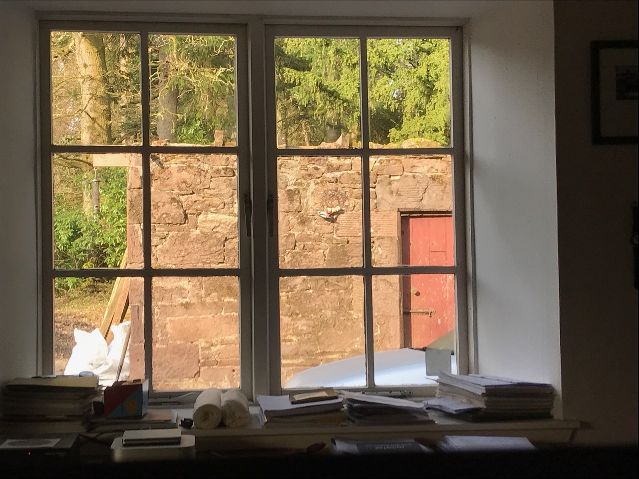
#WhatsOotMaWindae 42: Ay#WhatsOotMaWindae 21: Creiff & Strathearn, Perth & Kinross
One of our current groups participating in My Place Mentoring have sent in this pic…and there is so much going on! In the words of the photographer:
From the left is a DVD of a film about building sod houses featuring Daniel Postma. Beyond that is a cardboard stereo / 3D iPhone viewing box. Right of that is a small plastic car component which I aim to replicate with 3D printing (one day). Adjacent are two rolls of beautiful Chinese calligraphy paper, bought for painting and on which I want to experiment with printing. They were bought in the far east by my father in 1972 and I inherited them in 1984 when he died. Right of that is my grandfather’s standard issue Army notebook from WWI, set aside for the museum and in front of that you can just make out a copy of the last Scottish Civic Trust annual report.
Outside are the remnants of a building, built in or shortly after 1810 by James Gillespie Graham. There has been some crude raising of the wallhead in more recent years, using any old found stones and cement mortar. Suspended from the wall is a fat feeder with a female greater spotted woodpecker having its breakfast! My project for 2020 is to get a monopitch roof on this building – when I can buy timber!
#WhatsOotMaWindae 20: Carman Cottage, Carman Muir, West Dunbartonshire
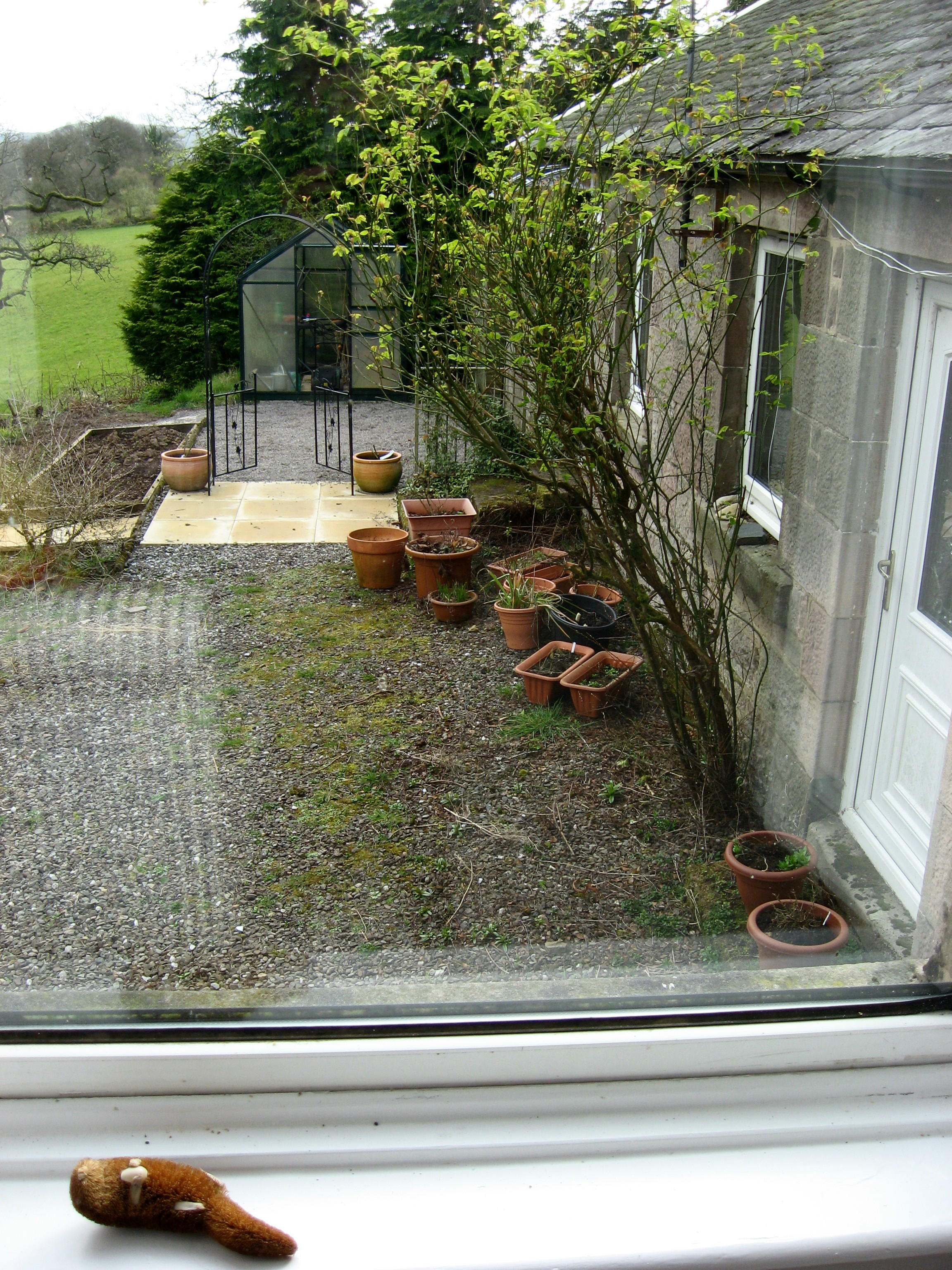
This lovely shot was sent in by one of our e-bulletin readers, who shared this wee history of their hoose:
This is the view from the main bedroom looking south. From the garden we can see Dumbarton Rock and the distant hills in the photo are in fact across the Clyde. We are surrounded by farmland and woods. No, that is not our extensive lush lawn in the photo, but the neighbouring farm’s field. Nearer to us there is evidence of my gardening – or lack of it. Pots awaiting replanting. Veggie patch awaiting replanting. The greenhouse awaiting new seedlings. Gravel awaiting weeding. But I have laid new pavers and set up an arch with optimistic climbing roses just showing new growth.
But this is not a gardening post! I should be talking about the built environment such as that close-by cottage. That is the Dog House. It was built about 1890 as the kennels for the estate of the extended family who descended from Scotland’s first novelist, Tobias Smollett. This Dog House originally had pens at the back. The rooms presumably for storage, dogs and someone who was the dog handler, but perhaps much like a ghillie. There is evidence of large gruel pots being over a fire in the front room. We restored and altered it as our guest cottage. And it served as my office for a while. And when my mother-in-law came to stay, she was put in the Dog House. Naturally. Don’t worry. It is fully fitted out and comfortable. Our main house, Carman Cottage, was built a little later.
We at Scottish Civic Trust love this shot and bit of local history – this wee cottage is just so cute! And the fact that it was originally a dog house is fascinating! The admirable attention to detail and finish of this cottage obviously reflect the importance of the estate owners. This is evidenced in the finely cut stone finish, which has remnants of beautiful tooling marks on both the door and window surrounds. And that slate roof?! Yes please! Thanks for sending this in!
#WhatsOotMaWindae 19: The Kelpies, Falkirk
Are those the incredible Andy Scott sculptures, The Kelpies, in the distance? Wow, what a view against the far off hills! These lovely creations are popping up to say hello over the rooftops of what appear to be a cluster of post-war homes. These homes would have been built to maximise the green space both in terms of gardens and communal spaces to complement and encourage outdoor activities.
The Kelpies sculpture takes the form of two 30-metre high horse-head sculptures. ‘Kelpies‘ are shape-shifting water spirits of Scottish legend, usually said to take the shape of a horse. The sculpture was completed by Andy Scott in October 2013 and is a monument to Scotland’s horse-powered industry and heritage. So apt here as they stand aside the Forth & Clyde canal, which was synonymous with horses back in its *hay* day! According to Visit Scotland, Kelpies are apt to represent Scotland’s horse-powered heritage not only because they often take the shape of horses, but also because “the mythological transforming beasts possess the strength and endurance of 100 horses; a quality that’s analogous with the transformational change of the area’s landscapes, endurance of its inland waterways and the strength of its communities.” Another site well worth a visit once we can travel out and about again!
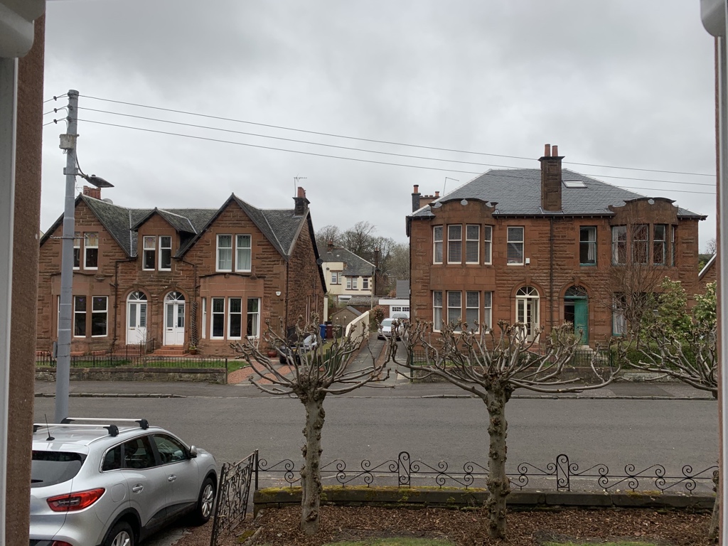
#WhatsOotMaWindae 18: Stirling
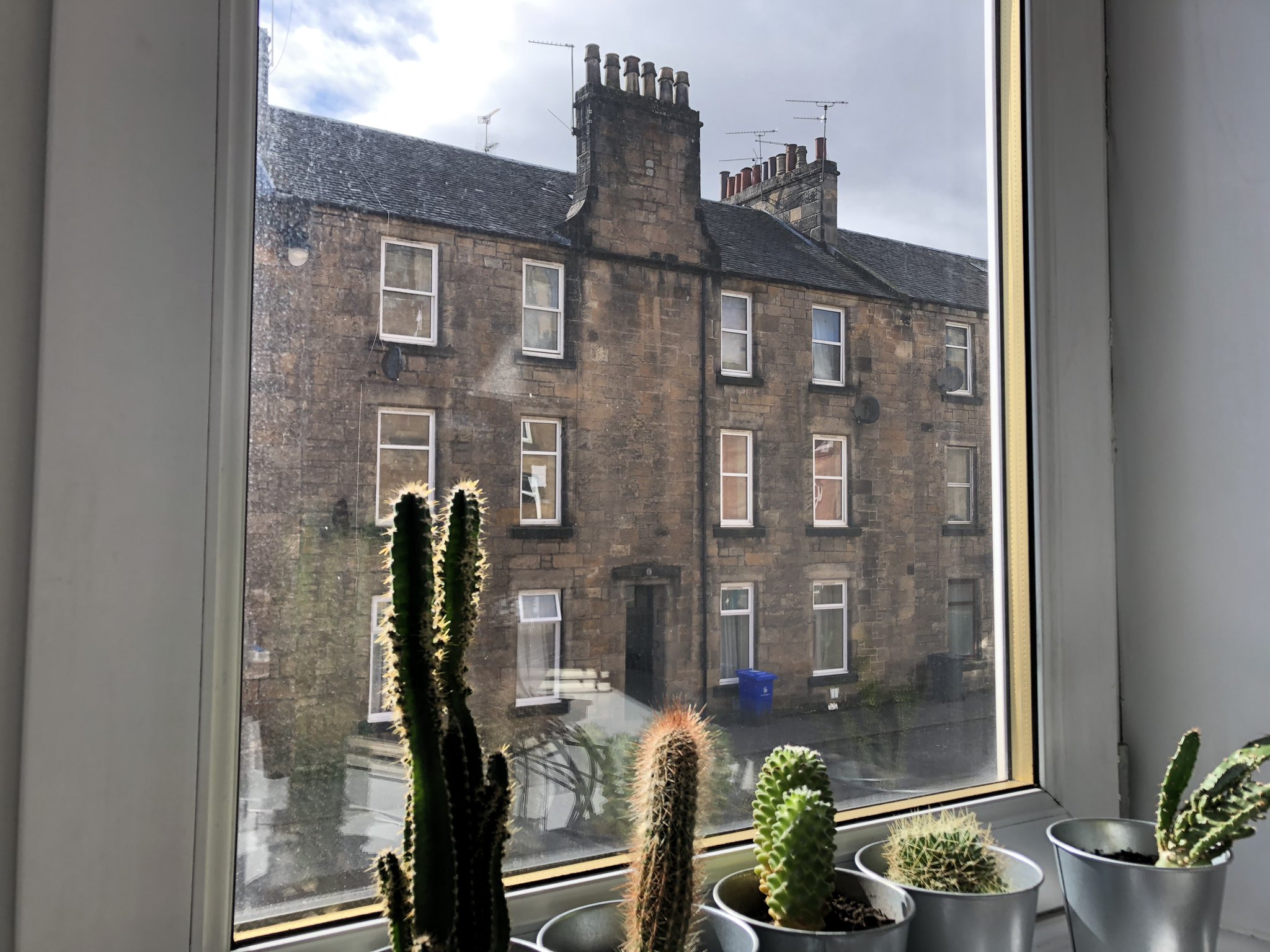
Firstly, this wee window ledge cacti garden is adorable! A green-fingered inhabitant no doubt…anyways, look at those lovely tenements just standing across the road looking proud! What is striking is the wonderful symmetry of this building dominated by that stunning chimney stack adorned with six pots. Chimney pots are (usually clay) pipes attached to the top of chimneys, and they have a functional and decorative purpose. Functionally, pots create a taller smokestack, which allows for a better draft. Drawing more air through the chimney and across the coals is critical for burning fires because fires need oxygen. Design-wise, most chimney pots are tapered, but they can be any shape. Some chimney pots are ornately decorated to represent the owner’s status and wealth, such as these chimney pots on Duart Castle on the Isle of Mull, or these chimney pots found on Hampton Court Palace. We’re also really loving the chimney’s curving detail where the stack meets the roofline. Such wonderful heritage out your window! It appears that the windows have since lost their lovely timber and are now replaced with plastic, a common sight nowadays unfortunately but this should not detract from this most handsome building. And is that a lovely wee hood mould over the door into the close we see?
#WhatsOotMaWindae 17: Bridgeton, Glasgow
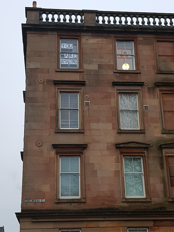
We’re loving the recent trend of folk communicating with neighbours by posting messages on windows (here are some examples from across Europe: an ‘Everything will be alright’ banner in Italy, a woman in Leeds using signs to get to know her neighbour’s cat and children across Scotland spreading rainbow cheer). This is a great way to use our built environment in innovative ways to stay connected during these tough times.
In addition to sharing uplifting messages on its windows, this wonderful tenement has so many yummy architectural details! So, where to begin – let’s go with the top and that refined balustraded parapet wall. ‘Balustraded’ describes the design of the wall – it means a low wall made of a row of short posts topped by a long rail. A ‘parapet’ describes the location of the wall – it means a low wall that extends upwards at the edge of a roof, terrace, balcony, walkway or other structure. This wall is not only visually gripping, but also has a functional purpose. This wall hides any view of the roof, as roofs were sometimes deemed ‘not for the eyes’ in previous building fashion. We can also see three wonderful blind windows (windows that have been blocked up) to the right with dinky pediments on two of the lower windows. It’s also great to see the (almost all timber) ‘two over two’ windows with the wee horns still visible. Window horns strengthen sash windows at their joints. Did you know that window horns differ according to geographic regions? Aberdeen has none as is the norm up there…mad! There are also four pattress plates visible (these are the small discs you can see). Pattress plates are structural ties, which basically tie one side of a building to the other. We’re also seeing what looks like a steel beam above the lower windows. This would suggest some structural movement took place within this building at one time and has now been stabilised. Crackin’ building…..no pun intended!
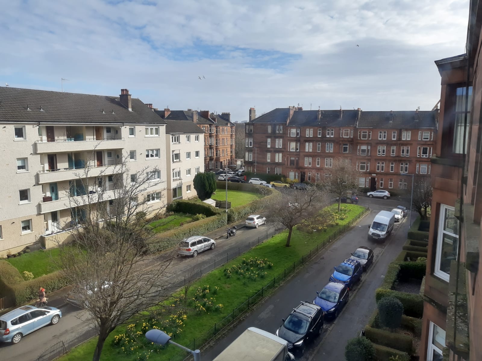
#WhatsOotMaWindae 16: Broomhill, Glasgow
This is a great example of creating a sense of place over an extended period of time, with the Edwardian red sandstone blocks (on right and centre of the shot) and the former social housing blocks dating from somewhere between the 1950s-1960s, we think (left of the shot). The idea of a central square is suggested by the tenement blocks on each side, all built to a similar height so that none overpowers the other, and with largely similar internal dimensions suggested by the window pattern (or fenestration as we nerds like to call it). It’s nice to see green areas have been added to the centre, particularly as they are clearly well-maintained. Heavily-overlooked communal areas like these make for great passive surveillance – ideal locations for bringing up children and building a sense of community. Other design elements that can enhance perceptions of safety, work to reduce crime and relatedly improve the health and wellbeing of a community are:
- (1) Active frontages: related to the design decision to put public green space in highly visible areas, designing ‘active frontages’ means designing buildings with views of the street. This increases passive surveillance of public areas, working to keep everyone safe.
- (2) Lighting: well-lit public spaces and routes can improve safety and surveillance and increase their use
- (3) Street crossings – providing street crossings at intersections, on busy streets and at key pedestrian routes of transit (to access shops, schools, parks, public transport) increases safe passage through a neighbourhood.
#WhatsOotMaWindae 15: Burnside, South Lanarkshire
Now aren’t these a beautiful pair of 19th century semi-detached, red sandstone delights! Similar in some ways but with lovely differences setting them apart. Firstly, they both have door cases with a wonderful keystone detail. Keystones are the wedge-shaped stone at the top of an arch. Arches are precision feats – each wedge in the arch is carefully crafted so that when assembled the arch can hold its own weight and bear the load from above. Arches have some advantages over horizontal beams – namely that they can hold up heavier weights. This is because, as seen in this diagram, the gravitational force downward on the wedges forces them together instead of apart. It is this same technology that underpins the massive, iconic Scottish landmark the Glenfinnan Viaduct! These houses have other details in common as well, such as outer storm doors with lovely fanlights above. Introduced in Britain in the early 18th century, fanlights were a design element added to increase the amount of light in previously dark hallways. Despite their similarities though, these houses differ on a few key details – while both have lovely slate roofs, the righthand house’s roof is hipped and the lefthand house’s roof is gabled. We’re loving the almost pediment’esque detailing over the upper windows on the right. Gorgeous! And it’s great to see timber windows in situ with remaining stained glass on the pair on the left. You could almost play a spot the similarities/differences game here!
#WhatsOotMaWindae 14: Blairfindy Castle, Moray
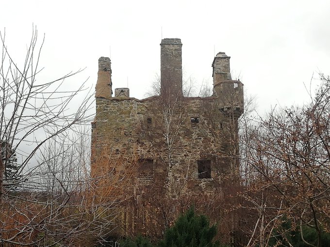
A cracking (in more ways than one!) 15th-16th century ruinous tower house, completed by John Gordon in 1564. The castle then passed to the Earls of Huntly in 1586 and thereafter was used as a hunting seat. In 1746, following the Battle of Culloden, Cumberlands troops destroyed the ‘house of Blairfindy’, likely referring to the destruction of Blairfindy Castle. The castle has remained ruined and unoccupied since then. Remnants of the lovely wee corner turret remain along with the imposing chimney stack in the centre of the picture. An interesting feature is the box machicolation which projects from the wall above the entrance (not seen from this angle, but can be seen in this shot). Machicolations are an architectural feature found on the top of defensive walls of medieval castles. They are openings in the wall that defenders could use to drop things like boulders, hot oil or boiling water onto attackers. Defenders could also shoot arrows through these openings. The word machicolation comes from the Middle French macher (to crush) + col (neck). However, Canmore notes that the machicolation box on Blairfindy Castle was likely added for aesthetic purposes, to give a ‘warlike appearance to what was essentially a residential building.’
.png)
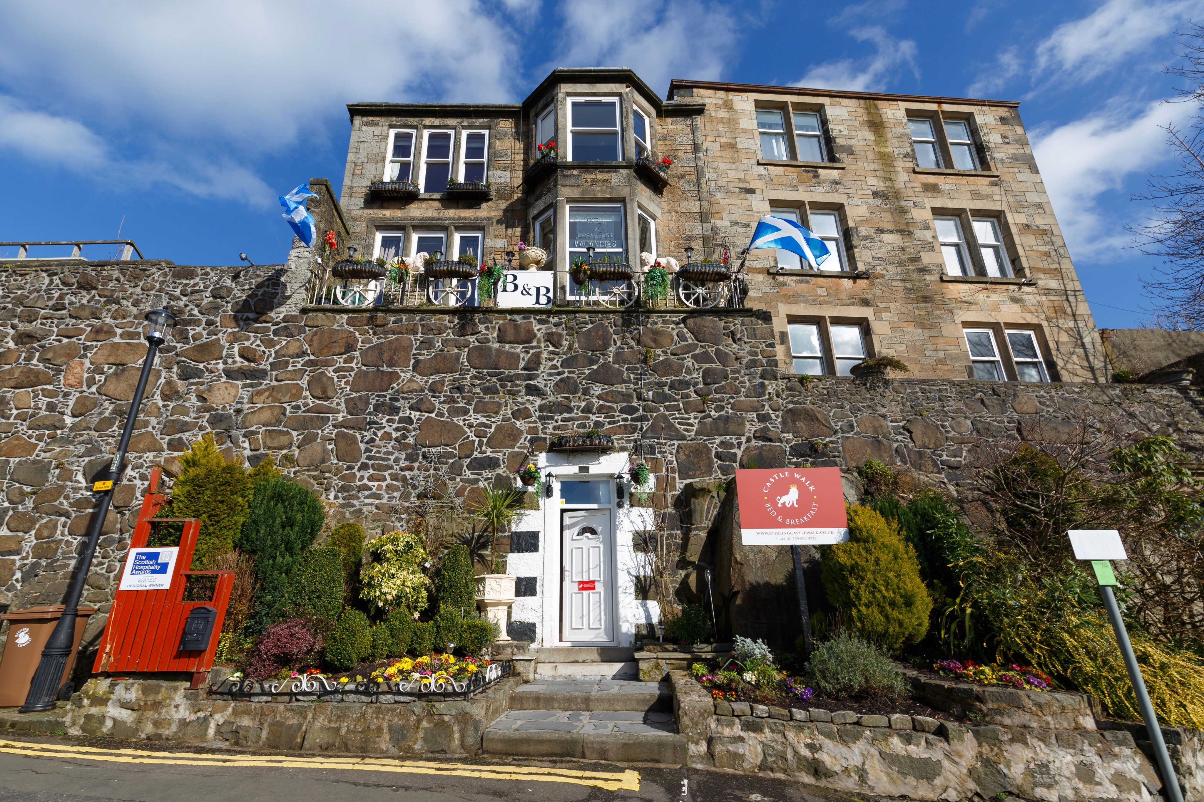
#WhatsOotMaWindae 13: Stirling Castle Walk B&B
Now this is some entrance into a B & B – through the actual historic Stirling Town Wall! Mad! (but brilliant). This wall is a Scheduled Monument and dates from the 16C. The walls were built In 1547, a time during the reign of King Henry VIII when the Royal Court at Stirling was continually under attack. The wall was built for defence and had gates which allowed passage in and out of the town. The wall is mainly of rubble construction (meaning the stones are undressed and not uniform in size) made with lovely lime mortar and looks stunning; lime mortar is crucial to its construction and longevity as this material is sacrificial (mortar is softer than the stone, so if the wall gets wet water will drain through the mortar. This means that the mortar will break down over time, but in doing so saves the stone. The mortar can be then re-pointed every few years). Lime mortar also allows for flexibility and movement. We can see good regular maintenance of the mortar here – there is no reason why these hulking walls won’t survive for several hundred more years!
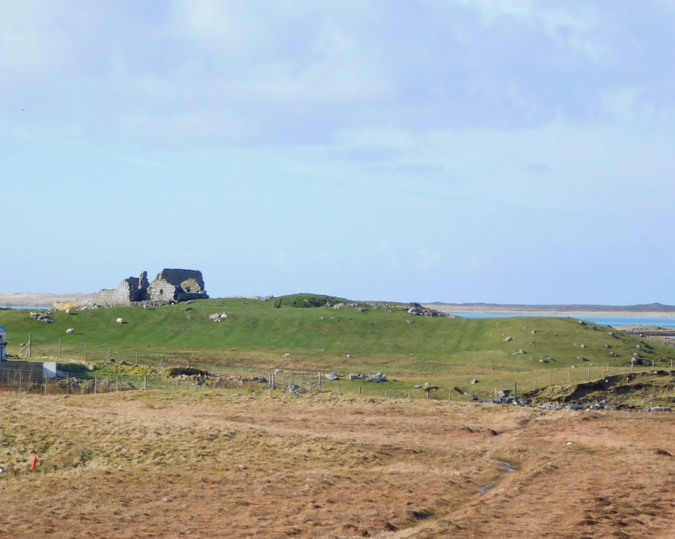
#WhatsOotMaWindae 12: Teampull na Trionaid & Feith na Fala, North Uist, Western Isles
A cracking view from North Uist for What’s Oot Ma Windae! The structure we can see in the distance of this shot is Teampull na Trionaid, or the Church of the Holy Trinity, said to have origins from the 12th century. The site went through several iterations right up to the 19th century, including functioning as a monastery. The west end of the church is the best remaining feature with walls up to 1m thick! This impressive structure lies adjacent to a field called ‘Feith na Fala’. Although this field looks sleepy and picturesque today, Feith na Fala means ‘Ditch of Blood’, in memory of the Battle of Carinish. The Battle of Carinish took place on this site in 1601 between the feuding MacLeod and MacDonald clans. It is said to have been the last battle fought in Scotland using only traditional weapons! You can get up close and personal with the site by checking out this virtual tour of Teampull na Troinaid.
#WhatsOotMaWindae 11: Callendar Park, Falkirk
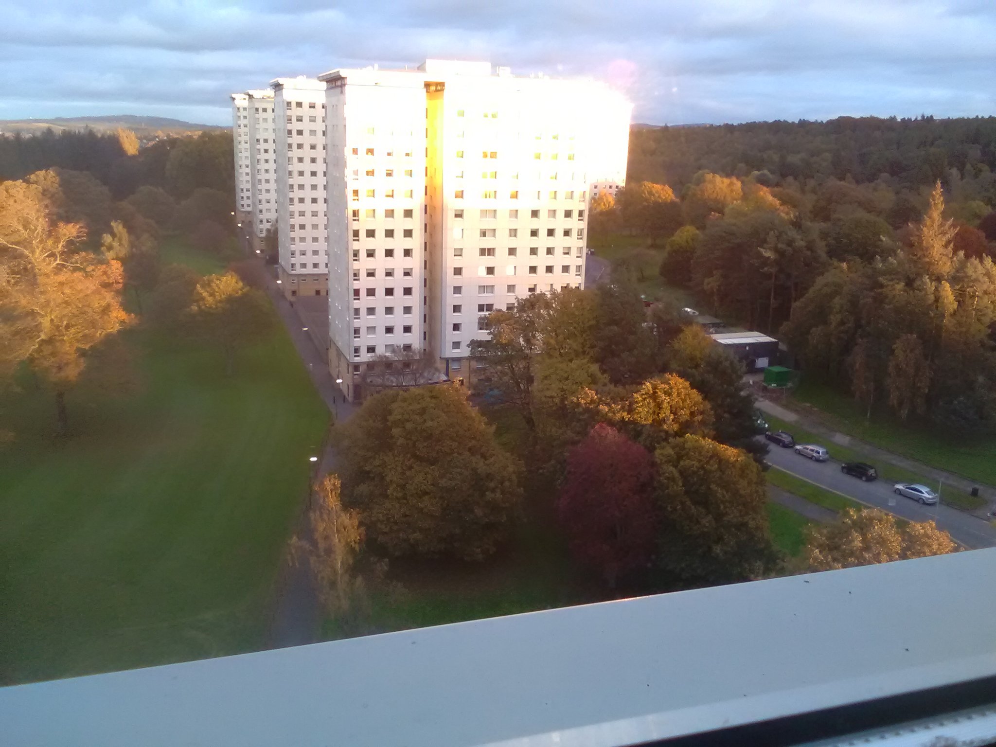
This is a great example of 1960s public housing, and notably set in lush surroundings. Callendar Park is a large 18th and 19th century park space, with history dating back to the Antonine Wall in 142 AD. As pictured here, there are five high rise tower blocks set within the park. Some blocks are known to have been built with shops at the first storey level! These blocks are an example of the modernist trend of building in mature landscapes. This housing development is similar to other sites in Britain such as the Alton Estate in Roehampton in Southwest London. The Alton Estate is a housing development built on Victorian gardens. The architects retained trees from the gardens and set the estate amongst picturesque landscaping.
#WhatsOotMaWindae 10: Stonehaven, Aberdeenshire
The primary building material in Stonehaven is granite, as is the case for the neighbouring city of Aberdeen (known as the Granite City). Granite is a popular building material in these parts due to its abundant local supply. Granite is a tough, unyielding material that can be difficult to quarry and carve, but is favoured as a building material for being strong and durable. Aberdeen granite has even been used in the construction of the Houses of Parliament and the Waterloo Bridge in London. In this shot here, we have a lovely granite rubble wall (meaning the stones are undressed and not uniform in size) with a side chimney stack and two ‘dinky dormers’ saying hello at the rear. Dormer windows are windows positioned in the slope of a roof and are ideal for maximising space by creating ‘rooms in the roof’. We’re also loving the wee finial at the front of this house!
#WhatsOotMaWindae 9: Edinburgh
We’re really taken by the mix of architectural features we can see on the immediately visible building. On the slate roofs we have a box dormer and a couple of hipped dormers. Hipped dormers have three or more sloped roof sections that come together in a peak, as opposed to a gable dormer (which has two sloped roof sections meeting at a top ridge, forming a triangular shape) or a box dormer (which is box-shaped, with a flat roof). One of the hipped dormers has delightful slate ‘cheeks’, meaning that the sides of the dormer are covered in slate, like the roof. We also have what would have been originally cast iron roof lights. All of these different windows have enabled attic rooms to become living spaces by introducing more natural light. Interestingly, on the elevation, we also see a ‘blind window’ (a window that has been blocked up) which may conceal structural timbers if this is an earlier build, or has been done simply to maintain consistency of the facade. This blind window would not be a case of ‘window tax’ concealment. This is a great view that just keeps on giving!
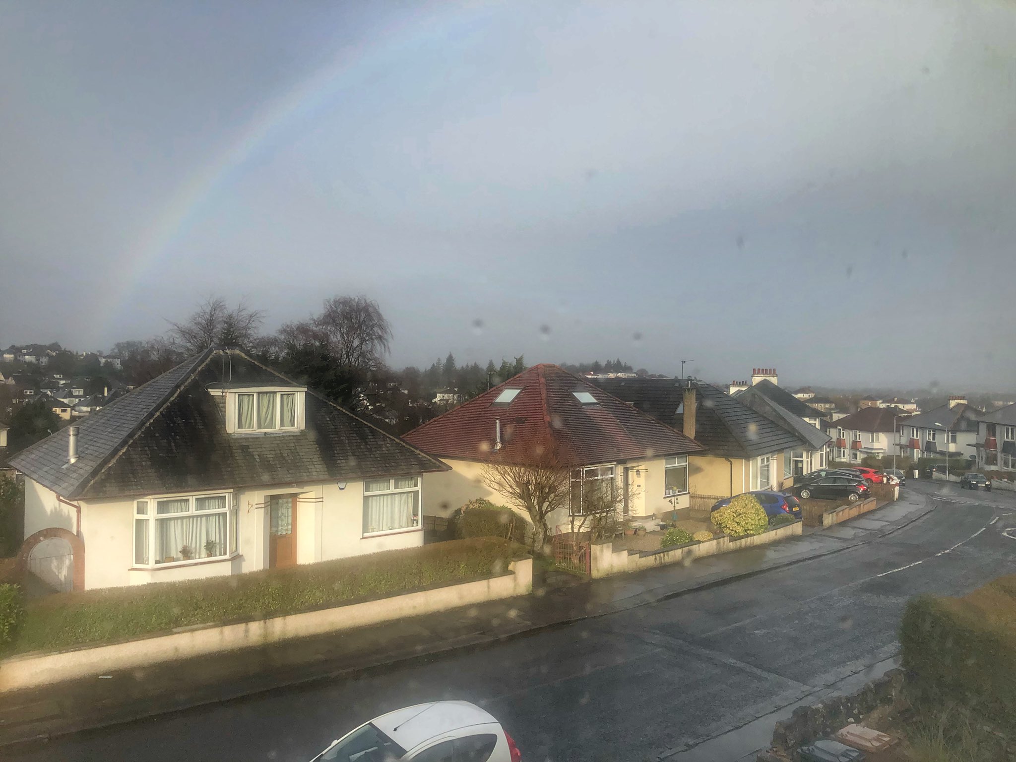
#WhatsOotMaWindae 8: Clarkston, East Renfrewshire
This popular suburb of Glasgow grew rapidly when the railway arrived in the 19th century, followed by the tram network in the 20th century. This resulted in the construction of a variety of residential homes, such as these very lovely dormer bungalows with incredible pyramid hipped style roofs (such an interesting architectural mix!). Dwellings like these really utilised their outdoor space as green space was seen as vital in a lot of early 20th century construction. As people moved to get away from crowded city centres and spread out in the suburbs, gardens became commonplace, particularly after WWI & II. Thanks for sending in this great shot – and framed by a beautiful rainbow!
#WhatsOotMaWindae 7: Newington, Edinburgh
With a bit of a similar look to #WhatsOotMaWindae 3 (below), here we have some great blonde sandstone tenements in the popular area of Newington, Edinburgh. Newington really took off from the 1820s onward, with a mix of villas and tenements being built. We can definitely see some original cast iron pipeworks and what appears to be some original timber windows, though hard to discern from here! There are also some rear boundary walls that marked out private plots of land and the communal part of the backspace. Note all of the chimneys in this shot! There are some interesting rear elevation chimney stacks – these are called wall head chimneys. Wall head chimneys are built on top of the front and back walls of a tenement. They normally carry flues from bedrooms. They had to be tall so the tops were above ridge height (the tallest point of the roof) where the airflow was strong enough to allow the chimney to draw. There are also some chimneys adjoining the tenements – these are called party wall chimneys. They are built on top of the gable wall and carry flues from the neighbouring tenement as well as from your own.
#WhatsOotMaWindae 6: Bannockburn, Stirling
Here we have a beautiful range of 2-storey workers cottages, all B-listed and were constructed in both the 18th & 19th century. Some still present the original three-window pattern with lovely ridge roofs. These houses have been beautifully restored with great attention (and respect) to historic details. Note the stunning archway which would have allowed vehicular access, primarily carts and agricultural, to the rear of the properties where outbuildings would have stood (and hopefully still do!). It’s also lovely the way these buildings follow the natural topography in both stepped fashion and curving the roadway. A great view!
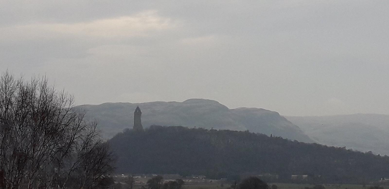
#WhatsOotMaWindae 5: Wallace Monument, Stirling
One of our followers is spoiled with this incredible view of the National Wallace Monument! The National Wallace Monument was designed by the Edinburgh-born Glasgow architect J. T. Rochead, and built between 1861 and 1869. Did you know that you can climb all the way to the top (a total of 246 steps!) for panoramic views over the area? From the top, you can see Ben Lomond and the Trossachs in the West, and through the Forth Valley past the city of Stirling and the Ochil Hills to the Pentland Hills in the East. Well worth a visit once we’re all out and about again! It is one of more than 20 Wallace Monuments which are located throughout Scotland, including the Wallace Monument at Dryburgh (1814) and Thomas Hamilton’s Wallace tower in Ayr (1833).
#WhatsOotMaWindae 4: Avoch, Black Isle, Highland
Another follower submission – a beautiful wee cottage! Built circa 19th century, this dwelling would likely have been originally harled due to its coastal location. Harling is a type of rough-textured exterior wall finish that helps make walls more weatherproof. This wee cottage was also possibly housing for the once thriving, local fishing trade. Stone copings are still evident running down from the chimney stack along with a wonderful slate roof. The dinky dormer is just too cute! Did you know that these houses usually run at right angles to the shore, with the gable end facing the incoming weather from the beach? This was done so that the strong gable end would take the brunt of the harsh coastal weather, protecting more fragile parts of the house, like the roof. This would be especially important if roofs were thatched (made from straw or reeds).
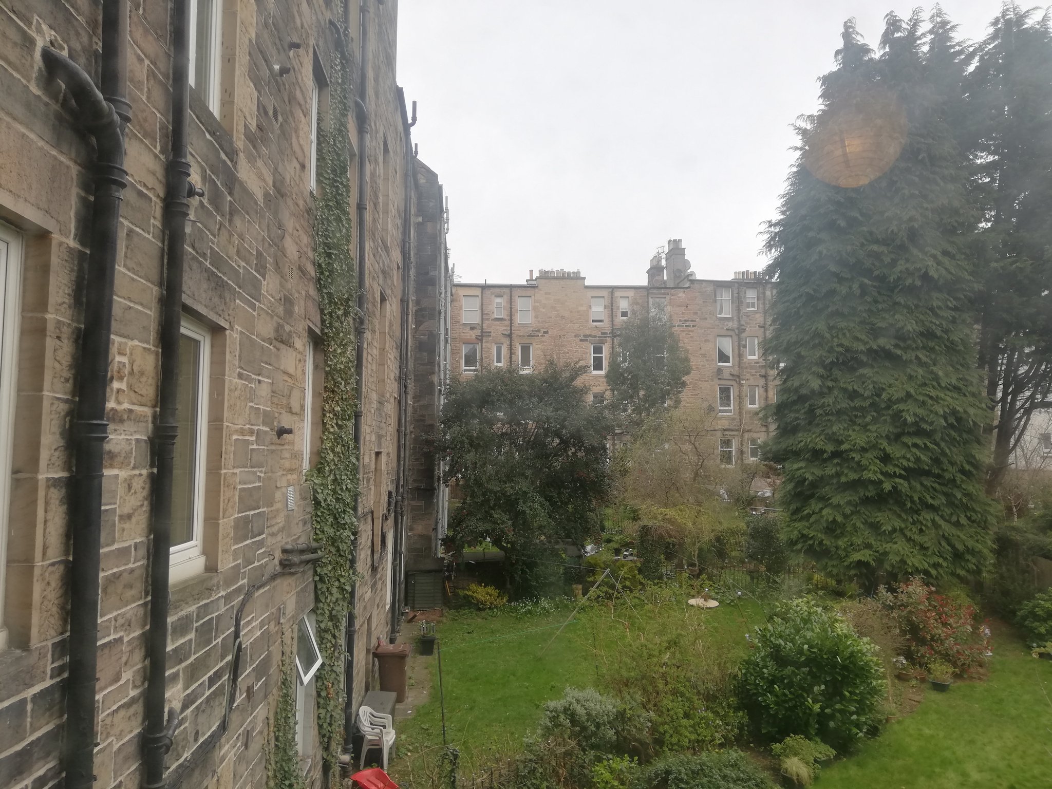
#WhatsOotMaWindae 3: Back green (location unknown)
Thanks to another lovely Twitter follower for sending in this shot. A lovely range of blonde sandstone tenements here with some beautiful, original cast iron downpipes still in situ, which is great to see! And such a green, lush back garden! Before tenements had internal bathrooms, communal loo and washing facilities were often in the back gardens along with shared drying greens. A lot of these original cast iron drying poles still exist. This outdoor space also allowed for recreation and social gathering. Perhaps nowadays a good space for some brief solo exercise and social distancing instead?
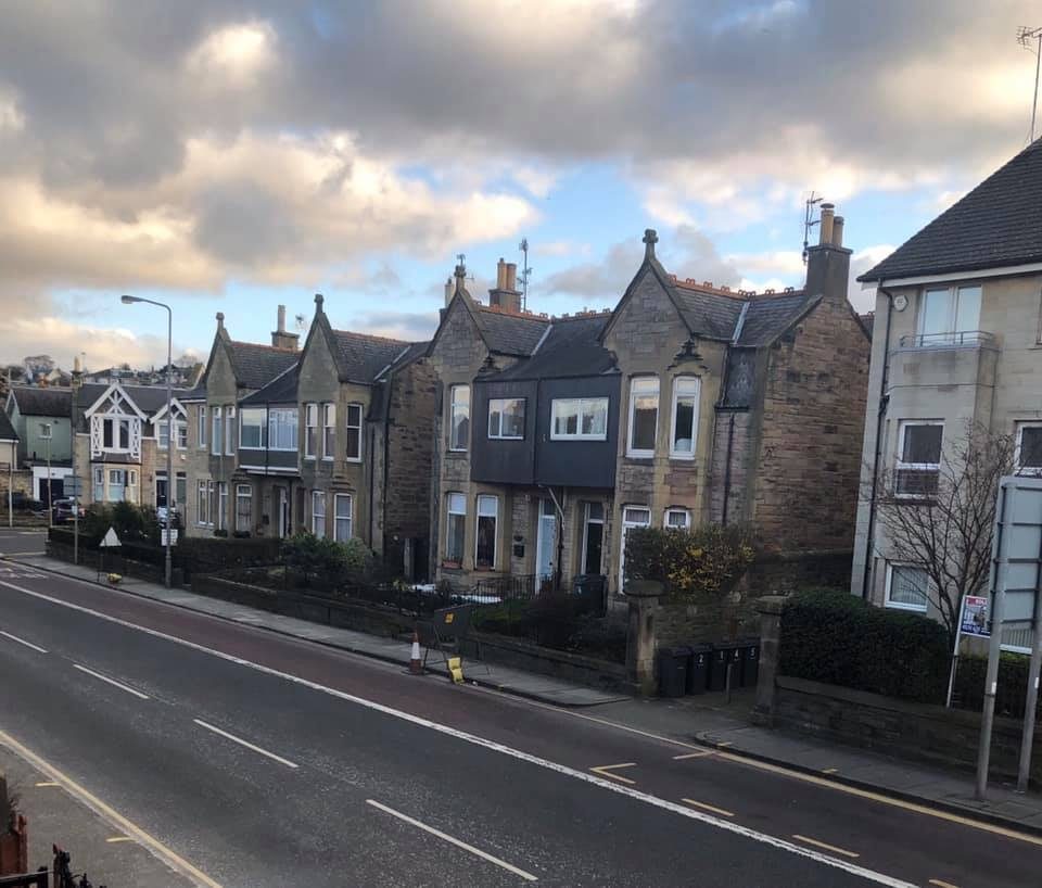
#WhatsOotMaWindae 2: Willowbrae, Edinburgh
A special shoutout to one of our Facebook followers for sending in this shot oot their windae in Willowbrae, Edinburgh. What a beautiful pair of semi-detached Victorian houses! Dwellings such as these sprung up outside Edinburgh in the late 19th/early 20th century, as wealthier folk wanting to escape the grime of the city moved to newly emerging suburbs. The semi-detached house design popped up as a compromise between the terraced houses in the crowded city centre and the detached villas further out in the countryside, where land was cheaper. By living in the suburbs, people could have access to a bit of green space and clean air, while also remaining closer to the city. The lovely dwellings pictured here have loads of yummy details such as the finials atop the front gables, beautiful detailed ridge tiles on the roof (the reddish tiles sticking up atop the roof) and chamfered upper windows (the chamfer detail can be seen on the nearest pair of houses above the upper corner windows). The Victorians loved their details! As you can see on these Victorian dwellings, bay windows and fronted gables with a three-part window style were very common. Bay windows were favoured because they let in more light than windows that are flush with the wall line.
#WhatsOotMaWindae 1: Dennistoun, Glasgow
As the city of Glasgow spread east in industrial times, Alexander Dennistoun employed the famous Glasgow architect, James Salmon in 1854 (who designed such iconic Glasgow landmarks as the ‘Hatrack’ and the Lion Chambers) to masterplan the new elegant suburb of Dennistoun. Terraces of fine villas sprang up and as the city grew, both red and blond sandstone tenements were constructed from the 1870s onward. These fine red sandstone tenements date from the turn of the century, approx. 1906 and though no original windows remain, they are still very, very lovely! Though plain to the eye, there are wonderful hood mould window details and stunning ashlar facades.
(#WhatsOotMaWindae research provided by the lovely Jamie McNamara, our My Place Mentoring Senior Project Officer)